| North Palisade by the LeConte Route * |
|
14,242-foot North Palisade is the highpoint of Kings Canyon National Park. The fourth highest peak in California and one of Californiaĺs fabled Fourteeners, North Palisade is considered by many to be the toughest of them all. Striking from all vantages, it is certainly a classic Sierra peak. The Palisade Glacier at the base of the peakĺs north face is the largest glacier in the Sierra. Steep on all sides, North Palisade offers many routes for climbers of all abilities, but even the easiest route is a technical climb.
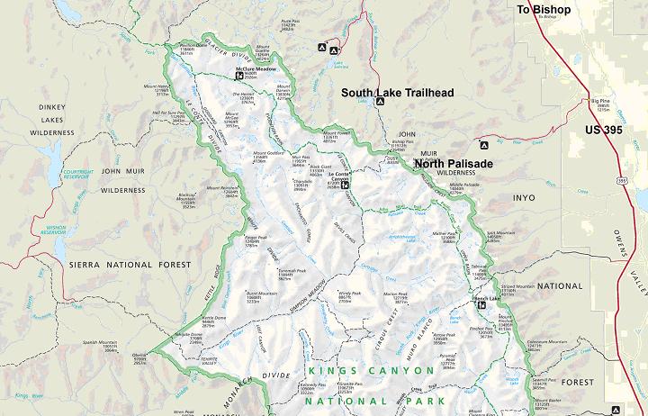
The adventure, normally done with a backpack, starts at the South Lake Trailhead and requires 19 miles, almost 6,000 feet of climb, and a Class 5.3 crux. To reach the trailhead, start at the southernmost stoplight in Bishop on US 395, turn west onto West Line Street, go west, turn left toward South Lake en route, and reach the trailhead at the end of the road at mile 18.5. The trailhead is near the dam at the north end of South Lake, just beyond the boat ramp.
Your backpacking approach is a semi-circular hike around the west end of the Palisade Crest that consists of a trail hike to Bishop Pass, a traverse of beautiful Dusy Basin, a crossing of rocky Thunderbolt Pass, and a descent into Palisade Basin. Thunderbolt Pass is not named on the USGS North Palisade Quadrangle or other maps derived from this source. Rangers on the trail are likely to ask to see your permit, so stow it in an easily accessible place. Do not confuse Palisade Basin on the south side of North Palisade with the Palisade Glacier on the north side of the peak.
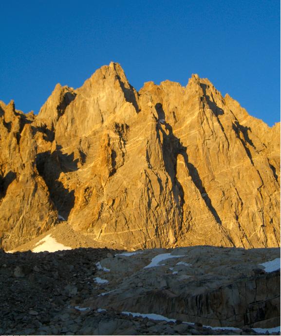
The summit climb from Palisade Basin is complicated, and I will just summarize it here. Contour and climb east across Palisade Basin to 12,300 feet. The LeConte Route starts up the broad, talus-filled gully to the southeast (right) of the Southwest Buttress. This is the middle and widest of the three gullies between four white buttresses, and it is called the Southwest Chute. This major chute goes all the way up to the U Notch, which is between North Palisade and 14,100-foot Polemonium Peak. Ascend the Southwest Chute to 13,200 feet, and look sharp to the west (left) side of the chute.
The key is a narrow, hard-to-see ledge that crosses the otherwise near-vertical cliff, and grants you passage out of the Southwest Chute into the next gully to the west. There is a black water streak on the cliff above the middle of the ledge that may be frozen early in the morning. Find, climb onto, and descend this exposed escape ledge. Go around a corner, scamper west to the base of the next gully, and scramble up this gully to 13,600 feet. Climb a 100-foot, Class 4 pitch on clean rock, then scamper up to the first of two famous chockstones, which are the routeĺs crux. To further complicate your ascent, there is often snow below both chockstones. Bypass the first chockstone on its left side (Class 4), and bypass the second chockstone system on its right side (Class 5.3).
Above the second chockstone, scamper 100 feet up and slightly right to a small, 13,800-foot saddle. Cross the saddle and enter a large gully to the right of the chockstone gully. Ascend this gully on loose rock and dirt, climb past yet another chockstone on its right side (easy Class 3), and continue up until the gully widens into the summit bowl. From here, you can see North Palisadeĺs summit rocks above you to the left. Climb toward the summit ridge running east of the summit, but do not go all the way to the ridge. One hundred feet below the ridge, find a ledge system with a white streak of rock in it, and follow this ledge up to the left for 100 yards. When a steep, 15-foot-high, east-facing wall blocks easy progress, leave the ledge and climb up to the right. Climb straight up for 20 feet then continue angling right toward the summit ridge up a steep, V-shaped weakness. From an unlikely stance, zig 10 feet downhill to the left to the top of an overhanging boulder. Wiggle 5 feet up a one-foot-wide crack to avoid a more exposed route. Go west toward the top through a roomy opening between huge rocks. Climb five feet up to a nice one-foot-square platform, then take a big step up onto a banister-like boulder. The last 20 feet to the summit boulder are easy!
You are on the highest point in Fresno County, and can look down to the Palisade Glacier on the peakĺs north side and marvel at its size. Lifting your eyes, you can scan much of the Sierra, and if the air is clear, you can squint south and just see Mount Whitney.
If you are planning a trip to this imposing peak, contact us, and we will give you our complete write up to try out!
|
|
Kings Canyon National Park is north of
and joined with Sequoia National Park. Sequoia National Park's highpoint is ubiquitous Mount Whitney. |
|
| North Palisade from Palisade Basin. |