Carbon County Highpoint Trip Report

BM Plateau of Castle Mountain via the Clay Butte Trailhead (12,612 feet)

Dates: August 19-22, 2006
Author: Adam Helman

Participants include Betty and Jerry Brekhus.

Note 1: All NAD27 UTM coordinates are in zone 12T.
Note 2: Click on any image for enlargement.

This effort was part of a larger journey collecting Colorado county highpoints in August and early September 2006.

Background

Betty and Jerry Brekhus live near Red Lodge - the county seat and largest community of Carbon County, Montana. Their status as the sole Montana "outpost" of county highpointing was emphasized by their recent change of E-mail address to, mtcohper(at sign)wildblue(period)net. Here, the "(at sign)" and "(period)" foil spammers and may be replaced by "@" and ".", respectively.

Although they have been avid hikers and backpackers for decades, a serious attempt at the highpoint of their home county was never realized - until now. Carbon County's Castle Mountain is not a trivial effort. Most approaches entail multiple days of backpacking from any of several trailheads - followed by a relatively benign, Class 2 summit day.

In 2005 Jerry E-mailed Edward Earl and myself, proposing a joint, multiday backpack. I accepted since eventually I would likely desire Castle Mountain anyway; and since I would be in the "neighborhood", the next summer, climbing in Colorado.

Two concerns existed, both of which could be "worked around" to mutual satisfaction: Fate does strange things to one's well-conceived plans. The Grand Teton climb is cancelled for reasons beyond my control. I would thus travel some 900 road miles just to climb one mountain. Normally I would balk at such a lack of economy. However I keep my word.

Secondly, I decide to meet the Brekhus's at the trailhead to ensure we are together for the nontrivial cross-country navigation to our Flat Rock Lake high camp. Again, fate intervenes - while in Cody, Wyoming, on the drive "up", I call the Brekhus's - who promptly invite me to stay at their home. In so doing I could pre-pack my overnight backpack, and enjoy a fine time rather than sleep at the trailhead.

Knowing my penchant for ice cream and interesting food, I accept the offer of a restaurant meal for dinner at the Brekhus's favorite eatery - one that specializes in the American conception of Mexican food. I finally got to enjoy Cincinnati chili, meaning, spaghetti topped with chili and adorned with cheddar cheese plus chopped onions.

The meal was characterized by chili in every course: my margarita is spiked with chili; the entreé has chili aplenty; and the desert is a plate of vanilla ice cream with a habanero chili sauce! The meal is both filling and delicious. The extra calories of the day would, I knew, enhance my stamina on the first hiking day - and, with over 4,000 Calories consumed and no exercise whatsoever, I certainly had overeaten this day.

Betty Jerry
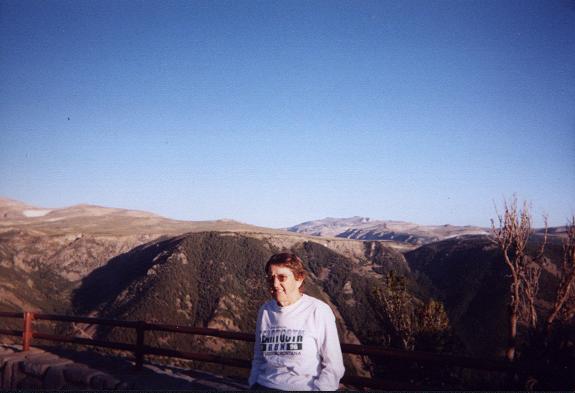
Betty at a Beartooth Highway pullout.
Jerry at the Beartooth Highway pullout.
The weather forecast was generally favorable - a most important consideration.

In the morning we caravaned on the photogenic Beartooth highway leading across the Montana / Wyoming boundary, arriving in time for an 8:36 a.m. trailhead departure.

Approach Hike

The backpack to high camp is long and arduous. Disappointingly, there is nearly as much downhill as uphill travel enroute. Thereby on the return one travels uphill a considerable amount.

The entire 12 mile journey to Flat Rock Lake, our intended high camp, was split into two roughly even-effort days by camping the first evening at Kidney Lake. I estimate Kidney to be 7 miles from the trailhead based on both map and my "gut feeling" for the level of effort.

One enters Montana during the hike, the trailhead being well inside Wyoming state. Indeed, with the driving included, I cross the Montana / Wyoming state line four times.

Kidney Lake
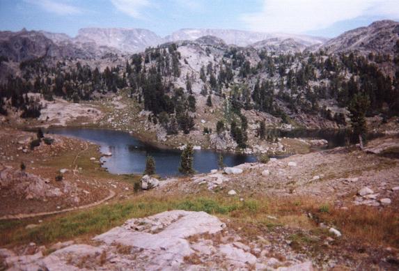
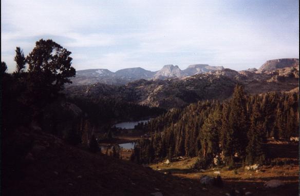
Kidney Lake - slightly over halfway to
our high Flat Rock Lake high camp.
The route to Kidney Lake is on-trail. I provide below several key waypoints for where the various trails intersect. A few miles after Kidney Lake the trail peters out to a mere path; and cross-country navigation becomes mandatory. Again, the waypoints below are essential information to remain on-track for Flat Rock Lake.

We consumed seven hours on the first day - and five hours the next in getting to Flat Rock Lake. Again, the main issue is the set of depressing downhill sections. In fact, the downhill travel nearly equals the uphill travel since Flat Rock Lake, at some 9,900 feet, is only 300 feet higher than the trailhead. Tim Worth and I independently estimate that the elevation gain is nearly 2,500 feet - so making for over 2,100 feet of elevation loss that must be made good on the return. These are values just for getting to Flat Rock Lake.

long way to go
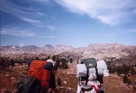
Betty (right) and Jerry gaze at our
yet-distant goal - Castle Mountain -
visible at center with the center snowfield.
This is grizzly bear country. A means of securing food overnight is highly recommended. At Kidney Lake, Jerry rigged lines high atop a tree for caching our food. At Flat Rock Lake, just above timberline, a bear-proof container stored our food at ground level.

Summit Day

The tent fly opens for a sky check - looks good with the Milky Way shining through. It is only 5:15 a.m., well before sunrise and even first light. That's OK because I knew this would be a long day ... but I could not have imagined how long!

We start together at 6 a.m. I then forge ahead with a walkie-talkie to relay important route information to Betty and Jerry. Our route contours around the south shore of Flat Rock Lake, then climbs the obvious gully, staying to the right (south) of the outlet stream from Forsaken Lake (shown as "Varve Lake" on the chart). Here, encounter a mess of boulders - there is no better way. This is certain to slow down Betty, I thought, as they had decided to cache hiking boots at Kidney Lake to save weight. They only had approach shoes for scrambling on these rocks - a mistake in hindsight. Too late now, however.

food caches
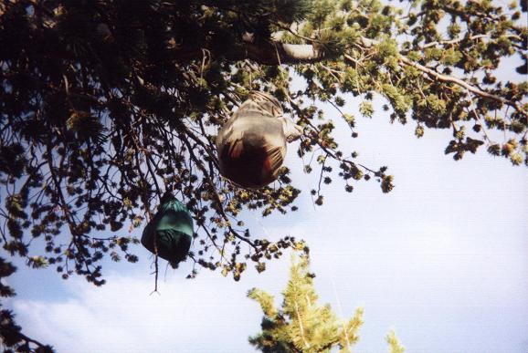
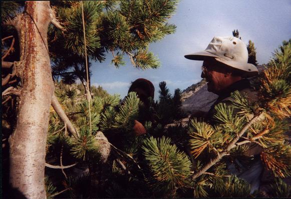
Our food caches hung in a nearby tree
while at Kidney Lake.
Above these boulders remain high rather than staying at stream's level. Else, you will get cliffed-out prior to reaching Forsaken Lake. A climber's path helps. At Forsaken Lake walk gingerly atop shoreline rocks to the base of Castle Mountain itself. Now, at some 10,500 feet, you will find both enormous granite slabs, not steep, with much tundra that appears to offer more solid footing - especially as some of the slabs may be wet from meltwater coming off the snowfield above.

Ascend the tundra and slabs by the path of least resistance - so reaching the base of a permanent snowfield on the left (west) side of the basin that extends, as of 2006, from about 11,600 to 12,100 feet.

securing caches
Jerry securing food cache lines
while at Kidney Lake.
View the summit ridge, at some 12,300 feet, as the topmost extent of the eastern "arm" of Castle Mountain. Indeed, Castle Mountain, especially as seen from afar, resembles an armchair with the two "arm rests" extending south from the summit plateau. To gain this ridge, at the snowfield's base you can either hike around the snow's eastern edge on scree and small talus; or head more directly to the summit ridge by climbing diagonally, and steeply, up larger talus and boulders. Do not stray far to the right (east), as this leads to very steep terrain with large boulders.

I decided upon the diagonal route, and relayed the two options to Jerry via walkie-talkie. It was about 8 a.m. - decent progress for two hours. Unfortunately Betty and Jerry were only just now getting to Forsaken Lake. I worry that they won't summit before afternoon storms pose an unacceptable threat. This is why (and in contrast to the approach hike) I decided to leave them: speed is safety on summit day. I would, however, wait for Betty and Jerry at the summit provided that the weather held.

The steepest climbing occurs just prior to reaching the summit ridge. Here, from 12,000 to 12,300 feet, acclimatization and resolve are your best friends.

Castle Mountain
Castle Mountain seen from Kidney Lake
is the rightmost massif on the far horizon.
Once atop the eastern "arm" the going is easy. The route turns left (north), and gains the summit plateau with ever-diminishing slope. Your highpoint is at the plateau's northeast edge and, as I approach, is identified by a simple cairn. Given the plateau's broadness I must explicitly advise the reader to remain as right (east) as possible rather than veering to the left (west) as the ascent continues.

I construct a small windbreak. Future highpointers should look for this obvious, artificial edifice amongst an otherwise random jumble of rocks. Again, stay to the right.

At 9:09 a.m. I reach the plateau's north end, find the BM Plateau benchmark, and marvel at the sheer verticality of Castle's other sides. One face is covered by a 75° ice sheet. It scares me just to look at it.

Flatrock Lake
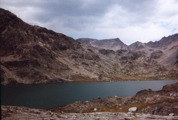
Flat Rock Lake from our high camp.
Castle Mountain is at center.
A large measure of Montana High Country stands arrayed for my viewing pleasure. Granite Peak, the state highpoint, is obvious to the northwest - as is Mount Wood - the Stillwater County highpoint. Together with Castle Mountain these are the three highest peaks in Montana.

I use the walkie-talkie only to hear a pair of automobile enthusiasts, way down in some valley, discuss seat upholstery. They hear my signal and tell me to get off "their" channel.

WHAT NERVE!

Realizing that I was not in any danger, I decide to have some fun -

"Begin your attacks now."

- a reference to the recently foiled attempts at blowing-up several transatlantic jetliners.

Silence pervades the airwaves. Then, in a shrill voice at the top of my lungs,

"I'll SKIN YOU to the LIVER."

After that utterance I did not hear from anybody again. My voice is so loud that I hear the echo reverberate about the cliffs - and it might have traveled as far as Betty and Jerry. What would they have thought?

I know that a long wait is in-store for me. After some lunch food (tuna fish in a spicy, Thai chili sauce and crackers; a granola bar) I return to the plateau's south edge and contact Jerry. The signal is scant but I can make out their position, just barely, from Jerry's report.

sunrise snowfield
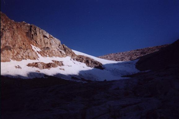
The permanent snowfield at 7 a.m.
from roughly 11,500 feet.
I return to the benchmark. Eat another bar. The wind increases, now uncomfortably so, and I put on all of my layers while constructing a windbreak to remain reasonably warm. A second trip to the plateau's edge.

A third trip at nearly noon. I have been here almost three HOURS. This time no reply - worrisome indeed. I consider the possible causes and arrive at two scenarios. Either Betty and Jerry have given up; or some accident has occurred that precludes their use of the walkie-talkie. In either case there was now no longer any point in remaining on this tabletop: I reluctantly descend at exactly 12 noon.

Much to my relief I find Betty and Jerry still climbing the steep scree slope just above the snowfield! I traverse to their position, choosing a route as to intersect where I anticipate they'll be rather than their current location.

BM Plateau
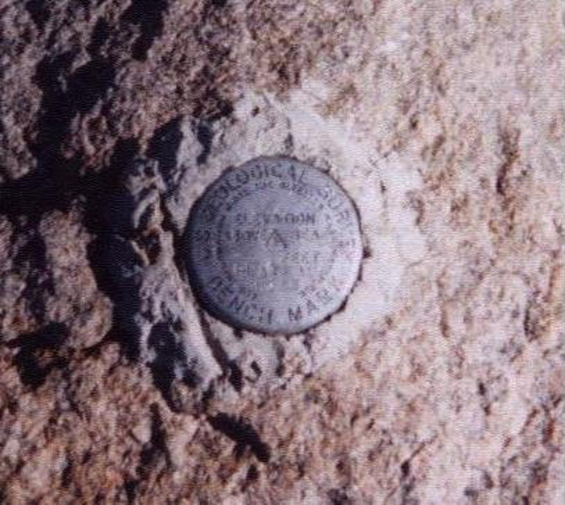
Reaching the benchmark "PLATEAU" signifies
a successful outcome.
Here, at some 12,000 feet, I encourage Betty to continue. Jerry forges ahead, reaching the 12,300 foot ridgeline in short order. I stay behind with Betty as we slowly trudge uphill while avoiding the largest boulders since she has only approach shoes.

Now on the summit plateau I advise Jerry to stay right.

Suddenly Jerry is at the summit!

As we near, Betty chants, "I think I can, I think I can" - and I reply, "I know you can, I know you can". We all meet at the benchmark cum windbreak. I take a picture of Betty and Jerry forming a "100" symbol with their fingers, for this is, by design, Betty's 100th county highpoint. Unfortunately I had just run out of film - and so the photograph was never really taken.

It is already 1:20 p.m. My descent is rapid - I am back at camp by 4 p.m. just in time for an afternoon thunderstorm. The tent shakes with high wind, and I'm inside just waiting for a break in order to exit and cook supper. Eventually I enjoy the scalloped potatoes with sausage - finding it really tasty with leftover white cheddar asparagus soup mix from the previous evening.

I spy Betty and Jerry at 6:30 p.m. as they descend that rocky section above Flat Rock Lake. They take a long break to filter water mere minutes from camp; and arrive 7:45 p.m - so making for a 13 hour 45 minute day!

Congratulations again.

Statistics and Summary

Kidney Lake is a good place to camp on a five day climb of Castle Mountain for the first night and the fourth night on the hike out - as done by Betty and Jerry. I walked out in one long march from Flat Rock Lake, consuming 7 hours 13 minutes total and making a four-day effort. I felt it "OK" to separate from Betty and Jerry on the hike out as by then everybody was familiar with the route.

For a three day climb of Castle Mountain, which is quite reasonable (and how I would proceed if alone), a camp can be established at Alp Lake some 10 1/2 miles from the trailhead. Said campsite distributes the overall effort into three nearly equal duration days. Summit day, for myself, would have stretched from six hours to eight - still a very acceptable amount.

The round-trip distance from trailhead to summit and back is estimated as 30 miles - including a six mile summit day from Flat Rock Lake's southern terminus.

The total elevation gain from the Clay Butte Trailhead is calculated as the net elevation gain plus twice the elevation lost in proceeding from the trailhead to Flat Rock Lake. We have, (12,612 feet - 9,600 feet) + (2 x 2,130 feet) = 7,272 feet. Our high camp was situated roughly 30 or 40 feet above the lake level, raising the total to some 7,350 feet for how Betty and Jerry traveled - and as anybody else is forced to do since the Flat Rock Lake outlet is not passible, i.e. one must climb the bluff that served as our campsite.

I descended some 25 feet, twice, while atop the summit plateau, to get a clear signal from Jerry's walkie-talkie. In addition, recall, I regained the final 600 vertical feet to "top-out" with Betty and Jerry. This additional 650 feet raises my total gain to 8,000 feet.

I am quite pleased to have witnessed this co-completion of Betty and Jerry's home county - and, as it was planned for well in-advance, Betty's 100-th county highpoint:

Betty - welcome to the Century Club!

Jerry Brekhus' Addendum

"Hi Adam, We have read and enjoyed your thorough trip report. I remember well the antics of forming the number 100 on top. The detailed route description should prove useful to future visitors to Montana's Carbon County HP.

We thought we had returned to Flat Rock Lake earlier than the report states. However, a check of our notes confirms that the time you give is indeed accurate. Your narrative, I feel, does well in conveying to the reader a sense of what the journey is like.

One minor detail we recall is that on summit day you were actually on your way walking 5 or 10 minutes before us, but I won't quibble over that. Of course, your lead widened as the morning passed.

The report doesn't reveal that the loss of radio communication was precipitated by my radio falling from my shirt pocket, hitting hard on the slab rock, and coming to rest in a puddle. So, a mishap had occurred, but fortunately to equipment, not to a limb. You have my permission to explain the mysterious radio silence from Betty and me. We were ready to turn back, but under the circumstances reached the decision to press on, being unable to announce a 180-degree turn.

Thank you for your part in our achievement. Knowing that you were up there waiting was the inspiration that kept us going.

On our hike from Flat Rock back to Kidney Lake we passed by the hill south of Alp Lake on the east side deviating slightly from the approach route. This link shows it. This worked fine. No need to clutter up the trip report with that since either side of the hill is passable. I just mention it for your personal information.

Since we had hiked out from Flat Rock Lake five years ago, there was no problem at all from our standpoint with you hiking out ahead of us. I must admit, though, that it was tougher with a full backpack.

--Jerry"

GPS-Derived Coordinates

Coordinates are provided for the approach to Flat Rock Lake only since navigational issues are largely "over" at that point. Once at Alp Lake hike northeast on the right (east) side of the Flat Rock Lake drainage, gaining 250 feet over 1.5 miles over easy grass. One rock slab is negotiated near a waterfall via Class 2 ledges.

GPS Waypoint (Easting, Northing) Topo chart (waypoint at cursor)
************ **************** *********
Automobile (607908 E, 4978279 N) at 9,587 feet click here
Trail junction. Stay north - straight. (607953 E, 4979969 N) at 9,300 feet click here
Trail splits - keep to left (NW). (608952 E, 4982295 N) at 9802 feet click here
Trail junction - disregard path leading E. (608708 E, 4982824 N) at 9870 feet click here
Trail descends into meadow near lake. (607390 E, 4983681 N) at 9349 feet click here
Along trail (607277 E, 4984904 N) at 9423 feet click here
Along trail (607096 E, 4985519 N) at 9963 feet click here
Trail 1/2 mile after Kidney Lake. (606322 E, 4986838 N) at 9748 feet click here
Top of descent to Green Lake. (606108 E, 4987092 N) at 9824 feet click here
Bottom of descent to Green Lake. (605747 E, 4987450 N) at 9374 feet click here
Enter meadow on trail. Stay on the rightmost (eastern) path. (605408 E, 4987715 N) at 9354 feet click here
Trail passes on right (east) edges of two lakes/streams. (605167 E, 4988470 N) at 9466 feet click here
Along trail (605380 E, 4988832 N) at 9567 feet click here
North end of traversing two lakes at their east margins.
Enter meadow, heading NE.
(605658 E, 4989184 N) at 9575 feet click here
Exit meadow, on-trail, heading east 500 feet. (606180 E, 4989503 N) at 9580 feet click here
Critical point. Head NE into a
rock-strewn gully leading to Alp Lake.
(606342 E, 4989471 N) at 9583 feet click here
South margin of Alp Lake. (606471 E, 4989594 N) at 9674 feet click here