Madison County Highpoint Trip Report
Date: August 6, 2010
Author: Adam Helman
"Hilgard Peak Dayhike"
note 1: All coordinates are in the WGS84 datum.
note 2: Mouse-click on any image for detail.
This effort was part of a larger journey
collecting Idaho and Montana county highpoints in August 2010.
From the junction of Montana Route 287 and US-191 drive 14.6 ATM west to FR985 which
is signed as "Beaver Creek Road. One ATM (Adam Truck Mile) is about 1.01 normal miles
since my odometer reads about 1% too low.
Drive gravel / dirt FR985 for 3.2 ATM to the
trailhead parking
at (44.91239° N, 111.36098° W) and 6,907 feet elevation.
A berm blocks driving farther north, with a "ROAD CLOSED" sign.
It starts to rain around 7:30 p.m., and continues unabated as the parking area starts turning to mud.
At 9 p.m. I get out of there and camp at a pullout along MT-287 about one-half mile east of FR985,
hoping for improved conditions by morning.
I arise at 3:37 a.m., return to the trailhead, and walk at 4:22 a.m. fully two hours before sunrise.
From the trailhead descend about 75 feet on a zigzagging trail to a bridge crossing. Then turn left (south)
and locate the trail perhaps 100 feet later as it starts heading generally west.
Breakfast is one-half hour into the route by headlamp, with Frosted Cheerios and 12 ounces
of mocha-cappuccino milk spiked with coffee grounds. More shouting "Aaaaaayooooo"
to alert any bears of my presence.
Dead reckoning suggests it is 4 miles to this
trail junction
at (44.89009° N, 111.42243° W) and 6,937 feet elevation. There are several stream crossings,
with by far the most cumbersome about one mile before this junction with multiple logs
and the option of walking through about six inches of water (during my visit).
Nearly all of the elevation gained to this junction is in the final mile.
|
Directions for crossing the ridge.
See the text for a description.
|
At this junction turn right (north) towards Avalanche Lake 1 mile later. The trail
meets Avalanche Lake
at (44.89374° N, 111.43494° W) and 9,106 feet elevation. Use this waypoint for returning
to the lake on your descent.
One must climb up to and over the east-west ridge to the northwest, descending into the next basin.
The ridge's lowest point is also the best place to descend it on the north side.
Steep scree abounds on the south slope there. In contrast, moderately-angled grass slopes lead to the
ridge some 1,000 feet west.
At 7:45 a.m. I pass the 9,400 foot contour, near where Edward Earl and Greg Slayden
once camped on an overnight climb at a small lake. Stated differently,
I've left early enough so as to match a summit hour for somebody who does this as an overnight
backpack and arises at 7 a.m. from their high camp.
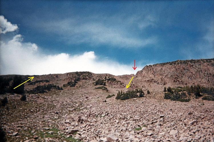
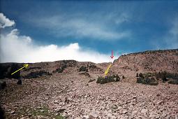
Given the above description and in reference to the first photograph proceed as follows. Bushwhack to the
ridge at 10,411 feet
with coordinates (44.90391° N, 111.45102° W) on the grass slopes (yellow arrow at left). Hike the ridge
east for 1,000 feet, losing 100 feet in elevation, and cross at its lowest point,
the saddle,
beneath the red arrow. Saddle coordinates are (44.90364° N, 111.44729° W) in case you are blinded by weather.
This plan avoids climbing nasty scree just south of the true saddle.

|
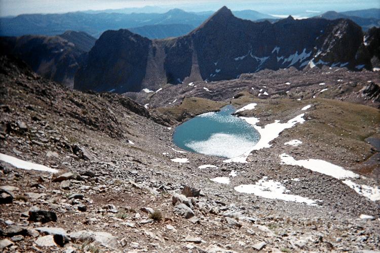
This two mile high pond
shimmers in sunlight as I reach
the climbing route's base.
|
Now descend north into the adjacent basin, aiming for
this point
at (44.90497° N, 111.44764° W) and 10,080 feet elevation almost directly downslope.
Lake Eglise
at (44.90779° N, 111.45099° W) and 9,990 feet is a good place to replenish water.
It is snowfield-fed, pristine-appearing, and hence seems much "cleaner" than Avalanche Lake.
I reach the summit complex's base at 10:25 a.m. However I am uncertain how to proceed.
I start climbing one seemingly promising lead, yet turn around after about 100 feet because it
is just too difficult for being the preferred route.
I then turn left and climb a second route with several Class 4 moves, consuming much valuable time.
I ascend all but the final 30 feet of that summit tower, only to note an untraversible ridge leading
to a higher tower that I cannot reach. There appear to be 4 summit towers, and I am near the top
of the wrong one.

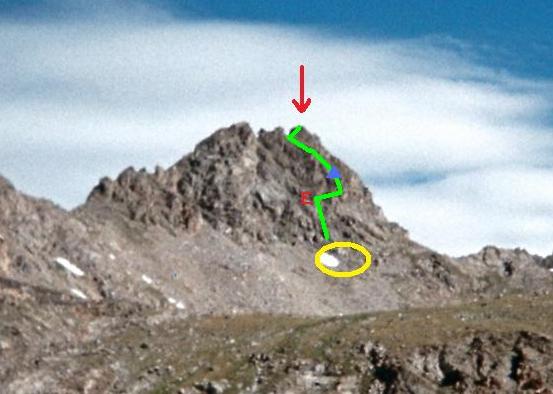
|
The suggested Class 3 route.
See the text for a description.
|
I let out a wail of uttermost despair, SO LOUD the echo is heard seven seconds later.
Crows (or ravens?) sound-off in the basin well below me in response.
I descend to the summit complex's base and traverse to what I guess to be the "correct" route's
starting point
at (44.91620° N, 111.45774° W) and 10,972 feet.
Thereby I find a Class 3 route (i.e. not Class 4 as commonly believed for Hilgard Peak).
With reference to the third photograph my description follows.
From the given point (within the yellow ellipse), climb the obvious weakness as a gulley for perhaps 100 feet
(green line) until it gets seriously steep with few handholds. Just before this section,
exit ("E") the gulley on its right side by first negotiating a precarious horizontal traverse
(along the gulley's right margin) for just two or three moves and with perhaps 20 feet of exposure.
Once outside the gulley proceed up the gradient, passing by a foot-tall pyramidal cairn (blue triangle)
after 20 or 30 vertical feet. Head on Class 2 / 3 terrain to the saddle between the rightmost (highest)
tower and that tower to its immediate left. From the saddle climb Class 2+ to the highest ground
on your right side.

|
Return to the ridge by crossing
at the indicated saddle.
|
I mistakenly climb the second-to-right tower and find a connecting knife-edge too risky to get over
onto the higher tower. I descend at most 50 feet, attain the indicated saddle, and summit at 12:20 a.m.
fully eight hours after leaving the trailhead.
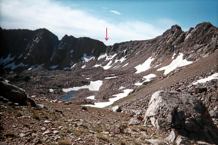
A final photograph shows under the red arrow exactly where one crosses the east-west ridge
for returning to Avalanche Lake. Unfortunately this does entail some 300 feet of talus climbing
followed by scree for the final 75 vertical feet to the indicated saddle.
I return in five hours from the summit - which is quite a contrast with the eight hours needed
on the ascent owing to attempting the rock climb three times. The watch reads 5:51 p.m. for an
elapsed time of 13 hours 29 minutes.
Estimated round-trip distance is 15 miles.
The net elevation gain is 4,400 feet. To this value I add 1,350 feet as
- 2 x (75 feet on initial descent to bridge + 50 feet estimated downhill on-trail);
- 400 feet from ridge at 10,400 feet to Lake Eglise at 10,000 feet;
- 300 feet in basin from 10,000 feet to 10,300 foot saddle;
- 100 feet summit attempt #1;
- 250 feet summit attempt #2;
- 50 feet from tower next to highpoint to bypass knife-edge ridge.
for a total elevation gain of 5,750 feet.
The necessary extra elevation gain beyond the net gain is calculated as the sum of
items 1, 2, and 3 above (950 feet); to which is subtracted 100 feet if one were to gain the
ridge at its lowest point (10,300 feet) in both directions rather than going to 10,400 feet
on the ascent. Thus the total elevation gain is 4,400 feet + 850 feet = 5,250 feet.
Climbing Hilgard Peak as a dayhike clearly requires an early start. Knowing what I do now,
a repeat effort would take roughly 12 hours.