Elevation: 8058 feet Prominence: 5909 feet Location: 49:14.4 N 116:49.4 W Backroads Mapbook: Kootenays (3rd edition), Map 3:G4 Climb Duration: One moderately long day. Elevation gain: 4500 feet Distance: 17 miles RT Difficulty: Class 2, a few sections of light brush but mostly a road walk.
Others in Party: Grant Myers. Climbed August 7, 2011.
Additional Resources:
Petter Bjørstad and Edward Earl have both written excellent trip reports.
Petter's reportEdward's report
We followed the route Petter describes since it avoids having to drive into an area restricted to vehicles.
His driving directions and distances are accurate and easy to follow. Moderate clearance vehicle
probably advisable. Some areas of the road were prone to slides with large rocks rolling onto fringes
of the road which otherwise appears somewhat maintained.
If one follows the alternative road system described by Edward Earl and takes the Pioneer Road turnoff
he mentions, then it is possible to drive to within a 1 hour scramble of the summit.
This assumes the gate Petter found locked is open and one is willing to risk getting caught in a
vehicle-restricted zone. If one wanted to try this approach I suggest using a mountain bike instead.
Since the route descriptions provided are detailed and accurate I simply add some photographs.
Photos6197: End of the road. Good camping here and beginning of the route.
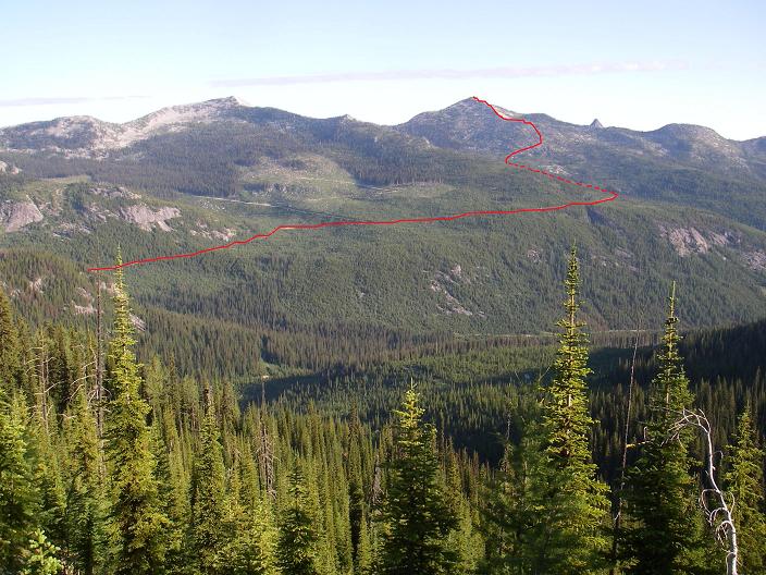
6199: Distant view of Kootenay (route indicated in red). Wood Peak is on the left.
6201: Pleasant roadwalking...
6205: Wood Peak from the basin below Kootenay.
6207: Another view of Wood Peak from the south ridge of Kootenay.
6209: Grant Myers on the upper ridge slope. Summit cairn is in the distance.
6212:
View of Kootenay from the spot where the route leaves the road. In front of the small rockpile
(right hand edge of the photo) is a track heading left into the upper part of the basin).
About one hour from here to the top.
Distant view of Kootenay (route indicated in red). Wood Peak is on the left.