Elevation : 7556 feet Prominence: 5564 feet Location : 51:12.3 N –119:14.1 W Backroads Mapbook: Kamloops/Okanagan, Map 52:D6 Climb Duration: One day. Difficulty: Class 2. Mostly a hike. All off trail with some moderate bushwhacking.
Ice ax in early season. Others in Party: Sue Madill Additional Resources: Grant Myers has written an excellent
trip report with photos.
Driving Instructions:
(Note: all mileage distances are merely rough estimates based on the mapbook -
I did not actually use my odometer to take measurements).
Drive to Chase B.C. on the Trans Canada Highway. Continue NE along Little Shuswap Lake
(perhaps 5 miles or so) and take the exit crossing over the water heading north on Squilax Rd.
Follow this paved road as it heads north and then east for (9-10 miles?) to the
Scotch Creek FSR (if you go too far you will cross the bridge over Scotch Creek
and the road will bend 90 degrees to the south).
Turn left onto Scotch Creek Road and drive this northward (for about 10?? Miles).
At a junction Kwikoit Creek road continues straight on to the north and Scotch Creek Road
turns right in an easterly direction. Take the Kwikoit Creek branch and continue north
passing the Cross Creek drainage and then the Scotch Adams FSR which heads left to the NW
(after perhaps 20 or so ??? Miles). Continue on the Kwikoit Cr. Rd for another 3-4 miles
and at a junction look right and keep and eye out for a sign indicating the way to Grizzly Lodge.
The road is a bit obscure and rougher beyond this point bending to the south before
heading east toward the lodge about 30 miles in. At the lodge take the small logging spur
heading uphill to the left for about another mile to the end of the road.
From the pavement it is a long haul; expect to spend a couple of hours on this part of the drive.
Description: See Grant Myers' report.
From the decommissioned road end at ~5000’ elevation, cross a creek and continue
a few minutes beyond entering an area of open logging slash. Head uphill and enter
the forest after 10 minutes or so. Follow the SW ridge of Pukeashun through
brush and forest.
After 2+ hours the ridge opens up
somewhat and becomes rockier and more clearly defined.
After some easy scrambling
the ridge becomes increasingly gentle
and the views expand in all directions.
The final portion to the
summit is merely a high-country stroll.
Photos (all from July 3, 2010)
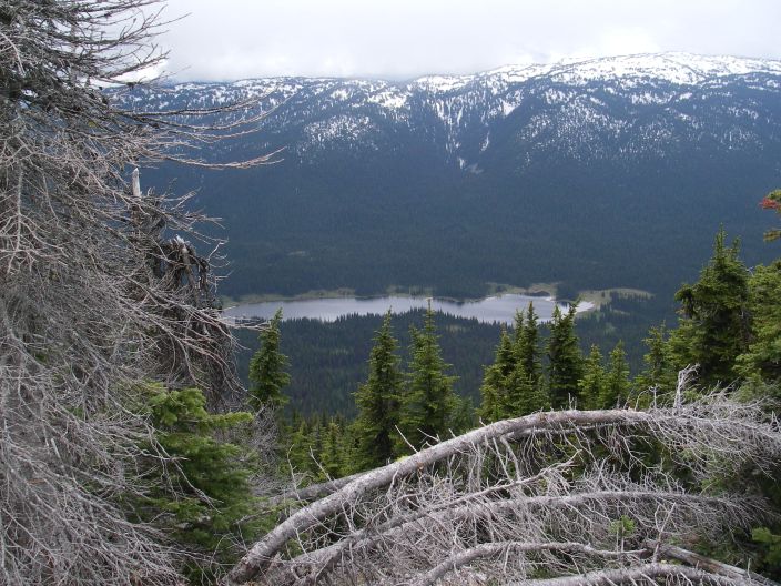
5284:
Bushwhacking typical of the lower half of the route. Grant and Duane reported
good snow cover in early June of 2010. Routefinding on the return can be a challenge -
GPS probably useful. Mosquitoes were voracious here in early July.
5285:
This is the point where the ridge opens up and becomes more defined.
A good place to take a break and recover from the brush-bash.
The route continues near the ridge climbing from right to left.
5287,
5288,
5289:
Views along the ridge. This is a very pleasant ridge walk with one narrower section
pictured in 5287. Snow may make this spot more difficult.
5291: Grizzly Lake to the south.
5292,
5293,
5295:
Higher up along the ridge. The background shows the generally gentle nature
of the surrounding area. The Grizzly Lodge and the approach road can be seen
in the upper right hand portion of 5293 and 5295.
5296,
5297,
5298:
The final half mile to the summit. This section is almost plateau-like.
The summit area cairn is pictured in 5297.
5300:
View looking north from the summit area.
5301:
Telephoto view to the northwest of Dunn Peak, another nearby ultra.