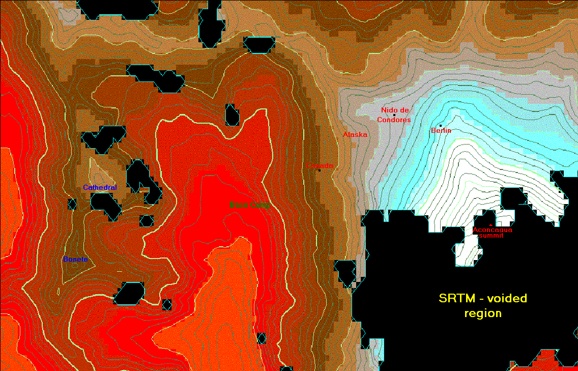
At this scale the Normal Route on Aconcagua is visible, commencing from the Base Camp at
Plaza de Mulas to the summit. The "acclimatization peaks", Bonete (about 5,060 meters = 16,600 feet)
and Cathedral (about 5,295 m = 17,370 feet), are visible to the west of Base Camp.
The indicated camp locations are highly accurate, having been transcribed onto the map using
GPS-derived coordinates taken by Petter Bjorstad on a
successful climb with his son Tor.
Elevation contours are shown, with the minor interval 200 feet and the major interval 1,000 feet.
The presence of these contours precludes a faithful rendition using a JPEG compression algorithm.
Thereby GIF compression was used, with the result that color gradients are not accurately rendered.
This compromise suggested that color gradients, although available in Winprom and certainly
more pleasing to the eye, be abandoned in favor of the solid colors described below.
The region displayed is 7.3 x 11.4 kilometers in height and width, respectively (4.5 x 7.1 statute miles).
Black regions are voids in the original, radar-based SRTM data and are not correctable for want
of interest
and funding by NASA - the National Aeronautics and Space Administration.
The largest such region exists on the south side of Aconcagua, so precluding display of the vertiginous
South Face. This region was labeled "SRTM - voided region".
Elevation key with values in feet. The accompanying triple of integers are the
exact HSB [Hue, Saturation, Brightness] values for each color.
 13,000 to 14,000 [ 10, 240, 120] ("red-orange")
|
 17,000 to 17,500 [ 20, 120, 120] ("light brown")
|
 14,000 to 14,500 [ 0, 240, 120] ("red")
|
 17,500 to 18,000 [ 20, 60, 150] ("very light brown")
|
 14,500 to 15,000 [ 5, 240, 105] ("red-brown")
|
 18,000 to 18,500 [ 0, 0, 180] ("gray")
|
 15,000 to 15,500 [ 10, 240, 90] ("orange-red-brown")
|
 18,500 to 19,000 [120, 160, 180] ("gray-light cyan")
|
 15,500 to 16,000 [ 15, 240, 75] ("orange-red-dark brown")
|
 19,000 to 19,500 [120, 240, 180] ("light cyan")
|
 16,000 to 16,500 [ 20, 240, 60] ("dark brown")
|
 19,500 to 20,000 [120, 240, 210] ("very light cyan")
|
 16,500 to 17,000 [ 20, 180, 90] ("medium brown")
|
 20,000 to 23,000 [120, 0, 240] ("white")
|