Jeff Davis County Highpoint Trip Report
Mount Livermore (8,378 feet)
Date: May 25, 2003
Authors: Adam Helman and Richard Carey
Note 1: All NAD27 UTM coordinates are in zone 13R.
Note 2: Click on any photograph for enlargement.
Overview
Mount Livermore lies on land owned by The Nature Conservancy (TNC), a privately funded organization
that preserves natural spaces from human exploitation. The public is allowed access on so-called
"open dates" - including the privilege of ascending Baldy Point, the highest peak of Mount Livermore.
Previous trip reports indicated the need for a membership fee to climb the mountain, and this under
the auspices of some appointed TNC guide. The TNC Texas web page
provides useful contact information for interested hikers. Here is a typical excerpt describing one
such open date:
05/25/03
Open Hiking Day
Time: 8:00 a.m. - 7:00 p.m.
Location: Davis Mountains Preserve
Cost: FREE - open to the public (donations welcome)
Other: The preserve will be open to the public for self-guided hiking and picnicking.
Please wear weather-appropriate clothing. Suggested items to bring include: water, lunch,
hiking boots, sun hat, insect repellent, binoculars, camera, and birding field guides.
Contact Karen Talley at 915-426-2390 or ktalley@tnc.org for more information.
Please note how, in contrast to previous trip reports, no fee is assessed for entering the preserve.
Perhaps the fees noted in previous reports existed because guides shepherded hikers to the summit.
Richard Carey and I were granted permission to simply drive our own vehicle through the preserve,
park at a specified roadblock (see details below) and hike on our own.
Approach to TNC
Mount Livermore is approached from the northeast via Madera Canyon. To reach this canyon one
first locates the entrance to TNC property at a
gate on the outside (southwest) curve of a sharp bend in paved route 118 as shown by the cursor on this
map.
This gate has NAD27 UTM coordinates (584802 E, 3396985 N).
The gate lies 28 miles southeast of Kent along route 118, and, from the opposite direction, 23 miles
northwest of Fort Davis along the same paved road. From the gate it is 0.4 mile east along route 118
to the western entrance of a picnic ground which makes for a good campsight (permits required to pitch
a tent), and 9.1 miles east along route 118 to the entrance of McDonald Observatory.
Drive Inside TNC Lands
An intricate road grid exists inside the gate. Drive south through the (opened) gate and note the set of
buildings 0.4 mile along the dirt road. From here it is 4.7 miles to a roadblock, from which we began
on foot. The following log describes the road navigation to said roadblock (distances in statue miles).
0.0 Zero odometer at main house (0.4 from gated entrance along route 118).
0.1 Drive SW one-tenth mile to a fork. Take the left fork and then immediately cross a fence.
1.2 Bear right at a road fork near a creek bed.
1.5 Pass a second creek bed. The road now shifts to a westerly direction.
1.9 Bear left at a fork near spot elevation 6137. Drive SW and then south.
2.4 The road has curved to the SE. Turn right onto a road trending SW and head up Madera Canyon.
3.1 Bear right at a fork near spot elevation 6095.
4.0 Pass a windmill on the right.
4.7 Arrive at a road junction. When we were there, further progress along the desired road was blocked
by a brightly painted pole.
Park at the cursor on this map
at UTM (579940 E, 3391786 N).

|
|
Mount Livermore
|

|
|
Baldy Point
|
Hike
Proceed on foot up Bridge Gap Road for 1.8 miles to Bridge Gap (7,311 ft), an elevation gain of some
eight hundred feet. Bridge Gap is a saddle with Richman Mountain immediately to the left (north) as you
approach it from below. A four wheel drive vehicle could make it here were the road to be open to traffic.
Bridge Gap is located at the cursor on this
map at UTM (580285 E, 3390120 N).
From Bridge Gap you may either continue on Mount Livermore Road for 1.3 miles to the summit area, or,
instead (and recommended) take the Limpia Chute Trail 0.7 mile until it intersects the Mount Livermore Road
halfway up to the summit area.
The Limpia Chute Trail is the left of two forks as seen from Bridge Gap, the right fork being Mount Livermore Road.
The trail drops perhaps one hundred feet before making a set of switchbacks up east-facing slopes to
a junction with Mount Livermore Road located at the cursor on this
map at UTM (580045 E, 3389493 N).
The trail is largely shaded and more enjoyable than a road walk. Take it until said junction.

|
|
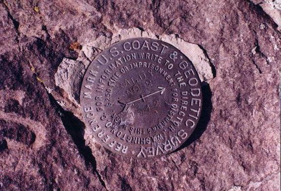
witness marker
|

|
|
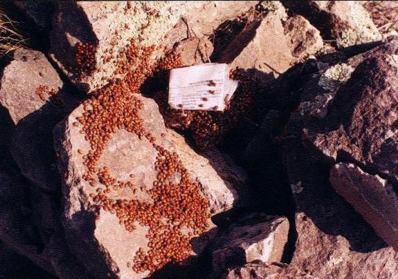
summit ladybugs
|
From the junction walk uphill along Mount Livermore Road as it winds around the upper slopes.
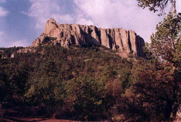
After some 400 or 450 feet of elevation gain encounter the summit rock massif - granite with
cliffs on all sides. There is a route up the north side of the west end, class 3 for 10+ feet and a
scramble for much of the rest. To get there proceed counterclockwise up a use trail, contouring along the
base of the rock massif, initially on the right (north or east) side thereof. After nearly circumnavigating
the base you arrive at a cairn signaling an obvious break in the cliff face (always on your left).
Proceed up this short, class 3 section and then scramble for the remaining few dozen vertical feet to the summit.
The summit, Baldy Peak, is located at the cursor on this
map at UTM (579229 E, 3389311 N).
On the summit Richard placed his signature, double red metal can register - complete with new notebook,
writing implements, and, of course, our own messages. Every summit rock hid hundreds, if not thousands of ladybugs.
It was impossible to eat lunch without some of them getting in the strangest and most annoying of places.
Views were good, as were the temperatures for late May.
The net elevation gain was 2,000 feet while the total gain was a bit more owing to the
downhill section along the Limpia Chute Trail.