King County Highpoint Trip Report

Mount Daniel (7,960+ feet)

Dates: August 9, 2009
Author: Adam Helman

note: All coordinates employ the WGS84 datum.

This effort was part of a larger journey collecting Idaho, Montana, and Washington county highpoints in late July and August 2009.

Approach drive

Along FS4330 and near the northern end of Cle Elum Lake is this junction, one with a bridge immediately afterwards along the left fork. Bear right rather than taking the bridge (which only leads to an overcrowded campground). Zero your odometer here as the route turns to dirt.

Roughly 7.5 miles later stay straight rather than bearing right. Complete the drive at mile 12.0 at a parking area for Cathedral Trail #1345. I took 45 minutes from the first junction, and perhaps a total of 1 1/4 hours from the highway.

Climb - Southeast Ridge

Dean Molen's report is just fine, as is Bob Bolton's summitpost description. I include here useful tips not already in posted reports.

Dean Molen notes, "At the first switchback as you go downhill, take the side trail instead of the switchback." That is not entirely true. As you begin to descend from Cathedral Pass there is a side trail leading south after only 20 or 30 feet. DO NOT take THAT trail. The desired side trail, leading north to Peggy's Pond, is encountered after hiking perhaps two or three minutes from the pass, and is at the sharp turn of a switchback that takes the main trail from north to south. I provide its exact coordinates in the table below. The side trail is signed "Peggy's Pond Trail 1375".

The trail loses and regains some 200 feet. There is a most annoying section where the trail is readily lost. Just stop and look very carefully for its continuation either above your sight-level or below it - it will not be at your own level.

The traverse from the saddle immediately north of unnamed 7662 northwest to the saddle west of the central summit of Mount Daniel was very sketchy. A climber's path was visible, and should be taken when located, as this portion is terribly hard-packed scree where it is most easy to slip. If ever there were a "crux portion" to my efforts it is here.

The final push leads one to a 20 or 30 foot tall rock pinnacle with summit register. I uncharacteristically signed-in and left quite shortly - clouds from the coast had lowered just enough to make navigation uncertain; and this is why I took so many GPS readings on the ascent.

summit register entry
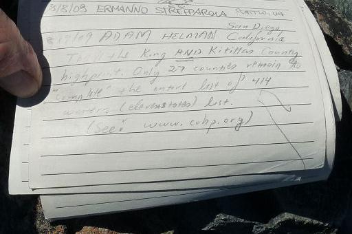
Summit register entry as photographed by
Don Nelsen roughly seven weeks later.

Now I find myself in a whiteout, and guess which ridge to descend, the southeast one, slowly finding my way over the talus. A most rudimentary path is soon located, I descend the steeper 200 foot section, retrace the level scree traverse, and take a real break at the saddle just north of unnamed 7662. Here I finally eat my "summit" sandwich as the cloud deck is no longer such an issue: I am now barely below it; and can easily follow the southeast ridge, without ever leaving it, clear to Peggy's Pond.

I make good progress until about 400 feet above the pond. Then, unable to find a path, I simply head in the general direction. Somehow I get off-course, and I bushwhack through very thick brush, with boulder slabs, only to find myself at that little tarn under Peggy's Pond. Looking back up it is hard to believe that steep, vegetated slope was just downclimbed.

The coordinates below are useful.

GPS-derived coordinates during the climb

GPS Waypoint (Latitude, Longitude) Topo chart (waypoint at cursor)
************ ***************** **************************
trailhead (47.54345° N, 121.09660° W) at 3,407 feet click here
Cathedral Pass (47.55059° N, 121.13066° W) at 5,601 feet click here
switchback (see text) (47.55070° N, 121.13400° W) at 5,536 feet click here
Peggy's Pond
west edge
(47.55645° N, 121.14293° W) at 5,580 feet click here
ridge west of pond (47.55606° N, 121.14909° W) at 6,066 feet click here
ridge west of pond (47.55602° N, 121.15513° W) at 6,706 feet click here
ridge west of pond (47.55763° N, 121.16854° W) at 7,370 feet click here
saddle immediately south
of east summit and north
of point 7662
(47.56080° N, 121.17123° W) at 7,579 feet click here
saddle west of central summit
and southeast of west summit
(47.56287° N, 121.17438° W) at 7,581 feet click here
top of 200 foot scree / snow slope (47.56301° N, 121.17575° W) at 7,747 feet click here
west summit (47.56503° N, 121.18092° W) at 7,977 feet click here

Cream cheese-frosted brownies added significantly to the enjoyment of my otherwise dry chocolate and peanut butter/chocolate granola bars by "shmearing" the icing and soft brownie on top of them.

I used neither ice axe nor crampons - they were carried to the summit, and back, for nothing at all.

Climb Statistics

There are two 50 foot elevation losses between 4,841 foot Squaw Lake and before Cathedral Pass; 200 feet of loss between Cathedral Pass and Peggy's Pond; plus 50 feet of elevation loss along the southeast ridge near and going around unnamed 7662.

The net elevation gain is 4,600 feet. Hence the total elevation gain is calculated as 4,600 + 2 x (200 + 3*50) = 5,300 feet.

I took 5 hours 9 minutes for the ascent and 10 hours 14 minutes round-trip including all breaks.