
|
Appendix F: GPS-Derived Coordinates and Elevations |
|
|
hese latitudes and longitudes are provided using the WGS-84 datum. Conversion to other datums and/or other coordinate systems (UTM, etc...) is facile with any handheld GPS unit.
Mountain
Location Description
Latitude
Longitude
Elevation (feet)
*********
******************
*******
*********
*************
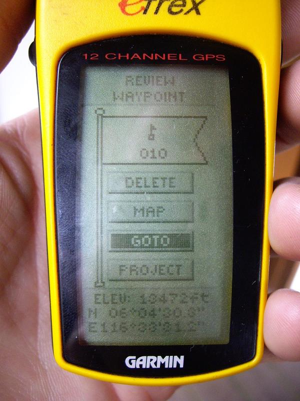
Gunung Kinabalu summit (Low's Peak) 6ş04'30.3"N 116ş33'31.2"E 13,472 Gunung Rinjani trailhead at park headquarters 8ş21'35.2"S 116ş31'27.5"E 3,753 8ş21'35.2"S 116ş31'27.6"E 3,773 8ş21'35.1"S 116ş31'27.6"E 3,777 rest stop 8ş21'35.6"S 116ş29'02.8"E 4,234 last rest stop 8ş22'34.0"S 116ş27'28.8"E 5,942 on steep hillside leading to crater rim 8ş23'04.6"S 116ş26'42.3"E 8,006 high camp 8ş23'37.2"S 116ş26'26.2"E 8,849 enroute to summit 8ş23'55.8"S 116ş26'25.9"E 9,757 enroute to summit 8ş24'23.4"S 116ş27'21.2"E 11,268 summit (no reading) alternative trailhead 8ş20'24.3"S 116ş30'03.4"E 3,299 Gunung Agung trailhead 8ş22'29.9"S 115ş27'13.4"E 3,133 8ş22'29.9"S 115ş27'13.4"E 3,139 west subpeak 8ş20'25.3"S 115ş29'54.8"E 9,975 summit 8ş20'29.4"S 115ş30'12.0"E 10,003 8ş20'29.2"S 115ş30'11.9"E 10,003 8ş20'29.2"S 115ş30'11.9"E 9,997 8ş20'29.4"S 115ş30'12.0"E 9,996 8ş20'29.4"S 115ş30'12.0"E 9,997 Bali/Java channel13 25 feet above sea on upper ferry deck 75 71
Gunung Raung Sumberwringin village 7ş59'34.8"S 114ş00'01.3"E 2,664 high camp 8ş05'00.6"S 114ş02'42.7"E 6,694 north crater rim (highest point reached) 8ş06'33.0"S 114ş03'32.2"E 10,442 Gunung Semeru trailhead as Ranu Pani 8ş00'37.3"S 112ş56'40.1"E 6,967 lake 8ş03'04.7"S 112ş55'03.5"E 7,896 high camp 8ş05'14.6"S 112ş55'03.3"E 8,810 Arcopodo camp 8ş05'39.2"S 112ş55'10.1"E 9,609 treeline and base of sandy scree slope 8ş05'55.0"S 112ş55'12.5"E 10,202 summit 8ş06'28.1"S 112ş55'19.1"E 12,137 8ş06'28.1"S 112ş55'19.0"E 12,135 Gunung Lawu roadbed nearest park entrance 7ş39'48.9"S 111ş11'14.1"E 6,307 post 1 7ş38'59.5"S 111ş11'19.1"E 7,302 post 2 7ş38'33.3"S 111ş11'16.3"E 8,118 post 3 7ş38'06.9"S 111ş11'04.0"E 9,457 post 4 7ş37'54.4"S 111ş11'11.7"E 10,329 summit 7ş37'38.5"S 111ş11'39.7"E 10,759 7ş37'38.5"S 111ş11'39.7"E 10,760 7ş37'38.5"S 111ş11'39.7"E 10,760 Gunung Slamet trailhead with ornate gate 7ş13'33.9"S 109ş15'51.4"E 4,970 7ş13'33.9"S 109ş15'51.4"E 4,972 post 1 7ş13'36.6"S 109ş14'50.5"E 6,474 post 2 7ş13'45.5"S 109ş14'28.4"E 7,425 post 3 (no reading) post 4 7ş14'01.5"S 109ş14'00.5"E 8,888 post 5 (high camp) 7ş14'07.7"S 109ş13'51.2"E 9,233 7ş14'07.8"S 109ş13'51.2"E 9,234 post 6 7ş14'13.1"S 109ş13'35.0"E 9,996 end of vegetation 7ş14'16.9"S 109ş13'25.6"E 10,524 summit 7ş14'20.5"S 109ş13'12.7"E 11,327 7ş14'20.5"S 109ş13'12.7"E 11,325 7ş14'20.5"S 109ş13'12.7"E 11,323 7ş14'20.6"S 109ş13'12.7"E 11,332 7ş14'20.6"S 109ş13'12.7"E 11,329 Gunung Kerinci Kersik Tua - road to trailhead 1ş46'33.2"S 101ş16'59.3"E 4,982 trailhead 1ş45'06.6"S 101ş15'35.8"E 5,270 1ş45'06.5"S 101ş15'35.7"E 5,308 standard high camp 1ş42'39.4"S 101ş16'03.5"E 9,919 1ş42'39.4"S 101ş16'03.3"E 9,902 current high camp 1ş42'20.6"S 101ş16'02.0"E 10,875 1ş42'20.6"S 101ş16'02.0"E 10,870 summit 1ş41'49.8"S 101ş15'52.1"E 12,499 1ş41'49.8"S 101ş15'52.2"E 12,500 1ş41'49.8"S 101ş15'52.1"E 12,500 1ş41'49.8"S 101ş15'52.2"E 12,501 1ş41'49.8"S 101ş15'52.2"E 12,502 Gunung Marapi turnoff on main highway 0ş23'30.3"S 100ş24'07.3"E 3,780 base of road to trailhead 0ş23'28.3"S 100ş24'09.5"E 3,817 trailhead at guide's hut 0ş23'36.1"S 100ş24'43.8"E 4,336 south subpeak 0ş23'36.7"S 100ş27'25.7"E 9,087 summit (not reached)
13Readings taken to calibrate the Gunung Agung summit elevations. Subtraction of the sea level overestimate, some 50 feet, from the summit GPS-derived elevations yields roughly 9,950 feet - a figure in close agreement with the published 9,944 foot summit elevation.
|
| Adam's GPS unit - Gunung Kinabalu summit |
| previous page - Bob Packard's Trip Review | next page - Overall Impressions and Conclusion |