|
Wyoming County Trip Reports | |
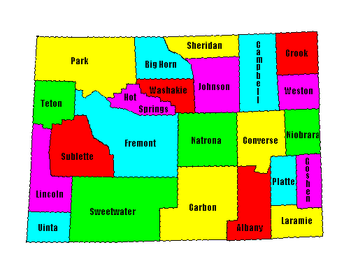
| USA Map / Home Page | Click on any county for highpoint information |
|
Of the 23 counties in Wyoming 2 pairs share common highpoints. All Wyoming county highpoints were completed by Bob Packard as of 1998. Later completers include Parnell Taylor, Jobe Wymore, Bill Schuler and Adam Helman. |
First Ascent List | Disclaimer |
topo chart / aerial image photos
Campbell County - North Butte (6,052 feet)topo chart / aerial image photos
Crook County - one point on Cement Ridge (6,674 feet)topo chart / aerial image photos
Goshen County - three unnamed points (6,120+ feet) on Rawhide Buttes West 7.5' USGS Quad Hot Springs County - Washakie Needles (12,518 feet)topo chart / aerial image photos
Johnson County - Cloud Peak (13,167 feet)topo chart / aerial image photos
Laramie County - BM Twin in Twin Mountains (8,146 feet) Lincoln County - Wyoming Peak (11,378 feet)topo chart / aerial image photo
Natrona County - BM Mine in Bighorn Mountains (9,121 feet) Niobrara County - three unnamed areas (6,100+ feet) on Silver Springs 7.5' USGS Quadtopo chart / aerial image photos
Sublette County - Gannett Peak (13,804 feet and State Highpoint)topo chart / aerial image photos
Sweetwater County - Pine Mountain (9,550 feet)topo chart / aerial image photos
Uinta County - unnamed point (9,780+ feet) on south state borderDisclaimer
Attempting to reach some of the points listed in this web site can be dangerous, and could lead to accidents resulting in injury or death. Some of the summits lie in rugged and isolated regions, where even minor mishaps can escalate into a life threatening crisis. Other locations lie on private property, military bases, and other areas where access is restricted. Trespassing in these areas can result in being arrested, shot at, or worse. Right of access to these areas is constantly changing, and access in the past does not guarantee present access. By use of this web page, the reader hereby releases the trip report authors, trip report compiler, and webmaster from liability for any injury, including but not limited to monetary loss, death, and other damages that might in any way be connected with this web site. FAIR WARNING: These are "armchair mountaineer" articles, an offering for amusement, not action. Many of these peaks are potentially life threatening, or are on private property. Adequate mountaineer training and/or owner's permission are required if you choose to pursue this list. The authors cited on this page accept no responsibility for injury, or any liability related to these route descriptions.| State Hyperlinks / Text-only Home Page | Introduction | Highpoint Superlatives |
| Highpoint Maps | Topographic Prominence | Highpointer Celebrities | Disclaimer |