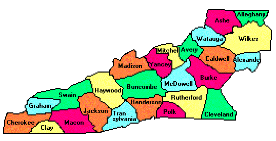
Montane North Carolina County Trip Reports |
Click on any region from the map above to access the corresponding reports. |
                        Click on any county for highpoint information. |
North Carolina main page | First Ascent List | Disclaimer |
        topo chart / aerial image
Alleghany County - Catherine Knob on Peach Bottom Mountain (4,175 feet)        area 1         area 2
Ashe County - The Peak (5,160+ feet)        topo chart / aerial image
Avery County - Grassy Ridge Bald (6,189 feet)        topo chart / aerial image
Buncombe County - Potato Knob (6,400+ feet)        topo chart / aerial image
Burke County - Long Arm Mountain (4,287 feet)        topo chart / aerial image
Caldwell County - Grandfather Mountain (5,964 feet)        topo chart / aerial image
Cherokee County - two areas and tri-county junction (5,040+ feet)        area 1         area 2         area 3
Clay County - Standing Indian (5,499 feet)        topo chart / aerial image
Cleveland County - Benn Knob (2,894 feet)        topo chart / aerial image
Graham County - Huckleberry Knob (5,560+ feet)        topo chart / aerial image
Haywood County - Mount Guyot (6,621 feet)        topo chart / aerial image
Henderson County - Little Pisgah Mountain (5,280+ feet)        topo chart / aerial image
Jackson County - Richland Balsam (6,410 feet)        topo chart / aerial image
McDowell County - The Pinnacle (5,665 feet)        topo chart / aerial image
Macon County - Standing Indian (5,499 feet)        topo chart / aerial image
Madison County - Sandymush Bald (5,152 feet)        topo chart / aerial image
Mitchell County - Roan High Knob (6,285 feet)        topo chart / aerial image
Polk County - Tryon Peak (3,280+ feet)        topo chart / aerial image
Rutherford County - Sugarloaf Mountain (3,965 feet)        topo chart / aerial image
Swain County - Clingmans Dome (6,643 feet)        topo chart / aerial image
Transylvania County - Chestnut Bald (6,000+ feet)        topo chart / aerial image
Watauga County - Grandfather Mountain (5,964 feet)        topo chart / aerial image
Wilkes County - Thomkins Knob (4,080+ feet)        topo chart / aerial image
Yancey County - Mount Mitchell (6,684 feet and State Highpoint)        topo chart / aerial image
Disclaimer
Attempting to reach some of the points listed in this web site can be dangerous, and could lead to accidents resulting in injury or death. Some of the summits lie in rugged and isolated regions, where even minor mishaps can escalate into a life threatening crisis. Other locations lie on private property, military bases, and other areas where access is restricted. Trespassing in these areas can result in being arrested, shot at, or worse. Right of access to these areas is constantly changing, and access in the past does not guarantee present access. By use of this web page, the reader hereby releases the trip report authors, trip report compiler, and webmaster from liability for any injury, including but not limited to monetary loss, death, and other damages that might in any way be connected with this web site. FAIR WARNING: These are "armchair mountaineer" articles, an offering for amusement, not action. Many of these peaks are potentially life threatening, or are on private property. Adequate mountaineer training and/or owner's permission are required if you choose to pursue this list. The authors cited on this page accept no responsibility for injury, or any liability related to these route descriptions.State Hyperlinks / Text-only Home Page | Introduction | Highpoint Superlatives |
Highpoint Maps | Topographic Prominence | Highpointer Celebrities | Disclaimer |