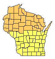
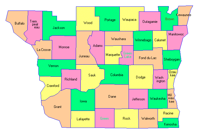
Small Wisconsin State Map South Wisconsin County Trip Reports South Wisconsin County Map

Click on either region from the map above
to access the corresponding reports.
Click on any county for highpoint information.

Wisconsin main page First Ascent List Disclaimer


    topographic chart (Acme)     aerial photograph (Flash Earth)                     Explanation

topo chart / aerial image scale:     normal     regional overview

(coordinates are not yet available)


Adams County - Spring Bluff (1,280+ feet)

Brown County - Morrison benchmark (1,015 feet)

        No trip reports have been posted.

Buffalo County - seven areas (1,360+ feet)

Calumet County - one area (1,130+ feet)

Columbia County - one area on South Range (1,480+ feet)

Crawford County - one area (1,320+ feet)

Dane County - Blue Mounds (1,489 feet)

Dodge County - one or two areas (1,230+ feet)

Fond du Lac County - one area (1,270+ feet)

        No trip reports have been posted.

Grant County - 12 areas (1,240+ feet)

Green County - one area (1,180+ feet)

Green Lake County - one area (1,090+ feet)

Iowa County - spot elevation on Blue Mounds (1,719 feet)

Jackson County - Saddle Mound and two areas (1,400+ feet)

Jefferson County - two areas (1,060+ feet)

Juneau County - two areas on Johnson Hill (1,380+ feet)

Kenosha County - one area (990+ feet)

Kewaunee County - Cherneyville Hill (1,020 feet)

La Crosse County - two areas (1,400+ feet)

        No trip reports have been posted.

Lafayette County - north mound of Platte Mounds (1,440+ feet)

Manitowoc County - USGS benchmark (1,047 feet) and three areas (1,040+ feet)

        No trip reports have been posted.

Marquette County - one area (1,320+ feet)

Milwaukee County - two areas (860+ feet)

Monroe County - two areas (1,448 feet) and multiple areas (1,440+ feet)

        No trip reports have been posted.

Outagamie County - two areas (1,010+ feet)

Ozaukee County - two areas (980+ feet)

Portage County - one area (1,320+ feet)

Racine County - USGS benchmark (952 feet)

Richland County - eight areas (1,300+ feet)

        No trip reports have been posted.

Rock County - Magnolia Bluff (1,050+ feet)

Sauk County - USGS benchmark at Sauk Point (1,593 feet) and one area (1,580+ feet)

Sheboygan County - Parnell Observation Tower (1,312 feet)

Trempealeau County - one area (1,360+ feet)

Vernon County - ten areas (1,380+ feet)

        No trip reports have been posted.

Walworth County - three areas (1,150+ feet)

Washington County - USGS benchmark (1,332 feet), Holy Hill, and one area (both 1,330+ feet)

        No trip reports have been posted.

Waukesha County - Lapham Hill and two areas (1,230+ feet)

        No trip reports have been posted.

Waupaca County - one area (1,220+ feet)

        No trip reports have been posted.

Waushara County - six areas (1,300+ feet)

Winnebago County - on county boundary (990+ feet)

Wood County - Powers Bluff (1,480+ feet)


Disclaimer

Attempting to reach some of the points listed in this web site can be dangerous, and could lead to accidents resulting in injury or death. Some of the summits lie in rugged and isolated regions, where even minor mishaps can escalate into a life threatening crisis. Other locations lie on private property, military bases, and other areas where access is restricted. Trespassing in these areas can result in being arrested, shot at, or worse. Right of access to these areas is constantly changing, and access in the past does not guarantee present access. By use of this web page, the reader hereby releases the trip report authors, trip report compiler, and webmaster from liability for any injury, including but not limited to monetary loss, death, and other damages that might in any way be connected with this web site.

FAIR WARNING: These are "armchair mountaineer" articles, an offering for amusement, not action. Many of these peaks are potentially life threatening, or are on private property. Adequate mountaineer training and/or owner's permission are required if you choose to pursue this list. The authors cited on this page accept no responsibility for injury, or any liability related to these route descriptions.


State Hyperlinks / Text-only Home Page Introduction Highpoint Superlatives
Highpoint Maps Topographic Prominence Highpointer Celebrities Disclaimer