|
Arizona County Trip Reports | |
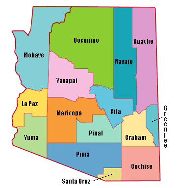
| USA Map / Home Page | Click on any county for highpoint information. |
|
All 15 Arizona county highpoints were completed by Bob Walko in 1977. see footnote There are 42 Arizona completers. |
First Ascent List | Disclaimer |
| External link: Scott Surgent's Arizona County Trip Reports |
topo chart / aerial image photos
Cochise County - Chiricahua Peak (9,759 feet)topo chart / aerial image photos
Coconino County - Humphreys Peak (12,633 feet and State Highpoint)topo chart / aerial image photos
Gila County - Myrtle Point, Promontory Butte (7,914 feet)Myrtle Point Promontory Butte photos
Graham County - Mount Graham (10,720 feet)topo chart / aerial image photos
Greenlee County - unnamed (9,441 feet)topo chart / aerial image photos
La Paz County - Harquahala Mountain (5,681 feet)topo chart / aerial image photos
Maricopa County - Browns Peak (7,657 feet)topo chart / aerial image photos
Mohave County - Hualapai Peak (8,417 feet)topo chart / aerial image photos
Navajo County - Black Mesa (8,168 feet)topo chart / aerial image photos
Pima County - Mount Lemmon (9,157 feet)topo chart / aerial image photos
Santa Cruz County - Mount Wrightson (9,453 feet)topo chart / aerial image photos
Yavapai County - Mount Union (7,979 feet)topo chart / aerial image photos
Yuma County - Signal Peak (4,877 feet)topo chart / aerial image photos
Disclaimer
Attempting to reach some of the points listed in this web site can be dangerous, and could lead to accidents resulting in injury or death. Some of the summits lie in rugged and isolated regions, where even minor mishaps can escalate into a life threatening crisis. Other locations lie on private property, military bases, and other areas where access is restricted. Trespassing in these areas can result in being arrested, shot at, or worse. Right of access to these areas is constantly changing, and access in the past does not guarantee present access. By use of this web page, the reader hereby releases the trip report authors, trip report compiler, and webmaster from liability for any injury, including but not limited to monetary loss, death, and other damages that might in any way be connected with this web site. FAIR WARNING: These are "armchair mountaineer" articles, an offering for amusement, not action. Many of these peaks are potentially life threatening, or are on private property. Adequate mountaineer training and/or owner's permission are required if you choose to pursue this list. The authors cited on this page accept no responsibility for injury, or any liability related to these route descriptions.| State Hyperlinks / Text-only Home Page | Introduction | Highpoint Superlatives |
| Highpoint Maps | Topographic Prominence | Highpointer Celebrities | Disclaimer |