East New York County Trip Reports |
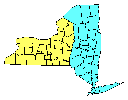
Click on either region from the map above to access the corresponding reports. |
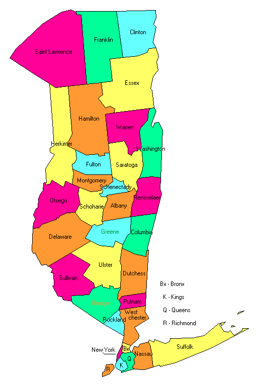
                        Click on any county for highpoint information. |
New York main page | First Ascent List | Disclaimer |
        Henry Hill area 1 area 2 area 3 area 4
Bronx County - one area 1,000 feet southwest of Riverdale Country School (280+ feet)        topo chart / aerial image
Columbia County - on Massachusetts state line 0.3 mile west of Alander Mountain (2,110+ feet)        topo chart / aerial image
Delaware County - on Bearpen Mountain (3,520+ feet)        topo chart / aerial image
Dutchess County - Brace Mountain (2,311 feet)        topo chart / aerial image
Essex County - Mount Marcy (5,344 feet and State Highpoint)        topo chart / aerial image
Fulton County - Pigeon Mountain (2,780+ feet)        topo chart / aerial image
Greene County - Hunter Mountain (4,040 feet)        topo chart / aerial image
Hamilton County - Snowy Mountain (3,900 feet)        topo chart / aerial image
Herkimer County - four points 1/2 mile S of Little Deer Lake (2,697+ feet)        area 1         area 2         area 3         area 4
Kings County - Kiaimie mausoleum in Green-Wood Cemetery (220+ feet)        topo chart / aerial image
Montgomery County - three areas near west county line (1,600+ feet)        area 1         area 2         area 3
Nassau County - six areas (360+ feet)        area 1         area 2         area 3         area 4         area 5         area 6
New York County - two areas (260+ feet)        area 1 area 2
Orange County - three points on Schunnemunk Mountain (1,660+, 1,662, and 1,664 feet)        area 1         area 2         area 3
Otsego County - two areas near eastern county line (2,420+ feet)        area 1 area 2
Putnam County - four points on Scofield Ridge (1,540+ feet)        area 1         area 2         area 3         area 4
Queens County - one area near Glen Oaks Golf Club (260+ feet)        topo chart / aerial image
Rensselaer County - Berlin Mountain (2,818 feet)        topo chart / aerial image
Richmond County - two areas on Todt Hill (410+ feet)        area 1         area 2
Rockland County - Rockhouse Mountain (1,283 feet) and Jackie Jones Mountain (1,280+ feet)        Rockhouse Mountain Jackie Jones Mountain
Saratoga County - Tenant Mountain (2,756+ feet)        topo chart / aerial image
Schenectady County - spot elevation (1,456 feet) and one area (1,450+ feet)        spot elevation         area 1
Schoharie County - Huntersfield Mountain (3,423 feet)        topo chart / aerial image
Suffolk County - High Hill and one area (both 380+ feet); Jaynes Hill (401 feet)        High Hill         Jaynes Hill         photos
Sullivan County - Beech Mountain (3,118 feet)        topo chart / aerial image
Ulster County - Slide Mountain (4,180 feet)        topo chart / aerial image
Warren County - Gore Mountain (3,563+ feet)        topo chart / aerial image
Washington County - Black Mountain (2,640+ feet)        topo chart / aerial image
Westchester County - BM Bailey (980+ feet)        topo chart / aerial image
Disclaimer
Attempting to reach some of the points listed in this web site can be dangerous, and could lead to accidents resulting in injury or death. Some of the summits lie in rugged and isolated regions, where even minor mishaps can escalate into a life threatening crisis. Other locations lie on private property, military bases, and other areas where access is restricted. Trespassing in these areas can result in being arrested, shot at, or worse. Right of access to these areas is constantly changing, and access in the past does not guarantee present access. By use of this web page, the reader hereby releases the trip report authors, trip report compiler, and webmaster from liability for any injury, including but not limited to monetary loss, death, and other damages that might in any way be connected with this web site. FAIR WARNING: These are "armchair mountaineer" articles, an offering for amusement, not action. Many of these peaks are potentially life threatening, or are on private property. Adequate mountaineer training and/or owner's permission are required if you choose to pursue this list. The authors cited on this page accept no responsibility for injury, or any liability related to these route descriptions.State Hyperlinks / Text-only Home Page | Introduction | Highpoint Superlatives |
Highpoint Maps | Topographic Prominence | Highpointer Celebrities | Disclaimer |