Small Virginia State Map Western Virginia County Trip Reports Western Virginia County Map

Albemarle Alleghany Amherst Appomattox Augusta Bath Bedford Bland Botetourt Buchanan Buckingham Campbell Carroll Charlotte Craig Cumberland Cumberland Dickenson Floyd Fluvanna Fluvanna Franklin Giles Grayson Greene Greene Halifax Henry Highland Lee Lunenburg Mecklenburg Montgomery Nelson Page Patrick Pittsylvania Prince Edward Pulaski Roanoke Rockbridge Rockingham Russell Scott Shenandoah Smyth Tazewell Washington Wise Wythe Bedford City Bristol City Buena Vista City Charlottesville City Covington City Danville City Galax City Harrisonburg City Lexington City Lynchburg City Martinsville City Norton City Radford City Roanoke City Salem City Staunton City Waynesboro City

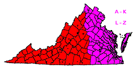
Click on either region from the map above
to access the corresponding reports.
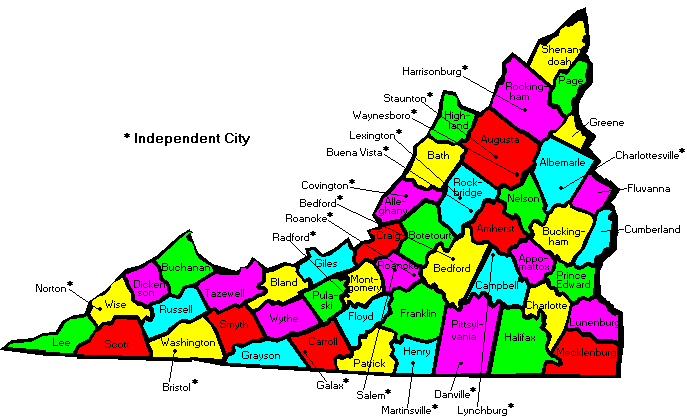
                        Click on any county or independent city name
                        for highpoint information.

Virginia main page First Ascent List Disclaimer


    topographic chart (Acme)     aerial photograph (Flash Earth)                     Explanation

topo chart / aerial image scale:     normal     regional overview

(coordinates provided by Don Desrosiers)


Albemarle County - Big Flat Mountain (3,389 feet)

        topo chart / aerial image

Alleghany County - Big Knob (4,072 feet)

        topo chart / aerial image

Amherst County - Bald Knob, Mount Pleasant, and Rocky Mountain (4,040+ and 4,072 feet)

        Bald Knob         Mount Pleasant         Rocky Mountain

Appomattox County - Kyles Mountain (1,161 feet)

        topo chart / aerial image

Augusta County - Elliott Knob (4,463 feet)

        topo chart / aerial image

Bath County - Paddy Knob (4,477 feet)

        topo chart / aerial image

Bedford City - one area (1,180+ feet)

        topo chart / aerial image

Bedford County - Apple Orchard Mountain (4,225 feet)

        topo chart / aerial image

Bland County - Chestnut Knob (4,409 feet)

        topo chart / aerial image

Botetourt County - Apple Orchard Mountain (4,225 feet)

        topo chart / aerial image

Bristol City - BM Wallace 9 (2,129 feet)

        topo chart / aerial image

Buchanan County - Big A Mountain (3,706 feet)

        topo chart / aerial image

Buckingham County - Spears Mountain (1,604 feet)

        topo chart / aerial image

Buena Vista City - on city line (1,340+ feet)

        topo chart / aerial image

Campbell County - three areas on Long Mountain (1,420+ feet)

        area 1         area 2         area 3

Carroll County - monument on state line (3,560+ feet)

        topo chart / aerial image

Charlotte County - two areas (790+ feet)

        area 1         area 2

Charlottesville City - one area (760+ feet)

        topo chart / aerial image

Covington City - one area with BM Nettleton (1,680+ feet)

        topo chart / aerial image

Craig County - White Rocks on Potts Mountain (3,940+ feet)

        topo chart / aerial image

Cumberland County - nine areas (520+ feet)

        area 1         area 2         area 3         area 4         area 5
        area 6         area 7         area 8         area 9

Danville City - fourteen areas (660+ feet)

        area 1           area 2           area 3             area 4           area 5
        area 6           area 7           area 8             area 9           area 10
        area 11         area 12         area 13         area 14

Dickenson County - Birch Gap on Pine Mountain (3,149 feet)

        topo chart / aerial image

Floyd County - Buffalo Mountain (3,971 feet)

        topo chart / aerial image

Fluvanna County - two areas (550+ feet)

        area 1         area 2

Franklin County - Cahas Mountain (3,571 feet)

        topo chart / aerial image

Galax City - on city line northwest of Ward Knob (2,900+ feet)

        topo chart / aerial image

Giles County - Bald Knob on Salt Pond Mountain (4,361 feet)

        topo chart / aerial image

Grayson County - Mount Rogers (5,729 feet and State Highpoint)

        topo chart / aerial image

Greene County - at north county corner near Hazeltop (3,640+ feet)

        topo chart / aerial image

Halifax County - one area (750+ feet)

        topo chart / aerial image

Harrisonburg City - two areas (1,760+ and 1,767 feet)

        area 1         area 2

Henry County - two areas on Turkeycock Mountain (1,840+ feet)

        area 1         area 2

Highland County - spot elevation (4,546 feet)

        topo chart / aerial image

Lee County - at north county corner near Potato Hill (3,760+ feet)

        topo chart / aerial image

Lexington City - two areas (1,180+ feet)

        area 1         area 2

Lunenburg County - five areas (630+ feet)

        area 1         area 2         area 3         area 4         area 5

Lynchburg City - one area (1,320+ feet)

        topo chart / aerial image

Martinsville City - one area (1,160+ feet)

        topo chart / aerial image

Mecklenburg County - three areas (600+ and 606 feet)

        area 1         area 2         area 3

Montgomery County - one area on Poor Mountain (3,760+ feet)

        topo chart / aerial image

Nelson County - Maintop Mountain (4,040+ feet) and two areas on The Priest (4,040+ and 4,063 feet)

        Maintop Mountain         Priest area 1         Priest area 2

Norton City - on city line (3,960+ feet)

        topo chart / aerial image

Page County - Hawksbill Mountain (4,050 feet)

        topo chart / aerial image

Patrick County - Rocky Knob (3,572 feet)

        topo chart / aerial image

Pittsylvania County - Smith Mountain (2,038 feet)

        topo chart / aerial image

Prince Edward County - two benchmarks on Lyle Mountain (780+ feet)

        topo chart / aerial image

Pulaski County - three areas on Walker Mountain (3,680+ and 3,699 feet)

        area 1         area 2         area 3

Radford City - Ingles Mountain (2,353 feet)

        topo chart / aerial image

Roanoke City - Mill Mountain (1,740+ feet)

        topo chart / aerial image

Roanoke County - spot elevation on Poor Mountain (3,928 feet)

        topo chart / aerial image

Rockbridge County - Rocky Mountain (4,072 feet)

        topo chart / aerial image

Rockingham County - Flagpole Knob (4,360+ feet)

        topo chart / aerial image

Russell County - Beartown Mountain (4,689 feet)

        topo chart / aerial image

Salem City - on city line (1,460+ feet)

        topo chart / aerial image

Scott County - on county line near Camp Rock (3,880+ feet)

        topo chart / aerial image

Shenandoah County - Mill Mountain (3,293 feet)

        topo chart / aerial image

Smyth County - Mount Rogers (5,729 feet and State Highpoint)

        topo chart / aerial image

Staunton City - BM City Park on Betsey Bell (1,940+ feet)

        topo chart / aerial image

Tazewell County - BM Maiden on Garden Mountain (4,710 feet)

        topo chart / aerial image

Washington County - Whitetop Mountain (5,520+ feet)

        topo chart / aerial image

Waynesboro City - one area (1,740+ feet)

        topo chart / aerial image

Wise County - BM High Knob No. 2 on High Knob (4,223 feet)

        topo chart / aerial image

Wythe County - Comers Rock (4,080+ feet)

        topo chart / aerial image


Disclaimer

Attempting to reach some of the points listed in this web site can be dangerous, and could lead to accidents resulting in injury or death. Some of the summits lie in rugged and isolated regions, where even minor mishaps can escalate into a life threatening crisis. Other locations lie on private property, military bases, and other areas where access is restricted. Trespassing in these areas can result in being arrested, shot at, or worse. Right of access to these areas is constantly changing, and access in the past does not guarantee present access. By use of this web page, the reader hereby releases the trip report authors, trip report compiler, and webmaster from liability for any injury, including but not limited to monetary loss, death, and other damages that might in any way be connected with this web site.

FAIR WARNING: These are "armchair mountaineer" articles, an offering for amusement, not action. Many of these peaks are potentially life threatening, or are on private property. Adequate mountaineer training and/or owner's permission are required if you choose to pursue this list. The authors cited on this page accept no responsibility for injury, or any liability related to these route descriptions.


State Hyperlinks / Text-only Home Page Introduction Highpoint Superlatives
Highpoint Maps Topographic Prominence Highpointer Celebrities Disclaimer