Small Pennsylvania State Map West Pennsylvania County Trip Reports West Pennsylvania County Map

Erie Warren McKean Potter Crawford Mercer Venango Forest Elk Cameron Clinton Lawrence Butler Clarion Jefferson Clearfild Centre Beaver Allegheny Washington Green Westmoreland Armstrong Indiana Cambria Blair Huntingdon Mifflin Juniata Fayette Somerset Bedford Fulton

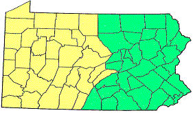
Click on either region from the map above
to access the corresponding reports.
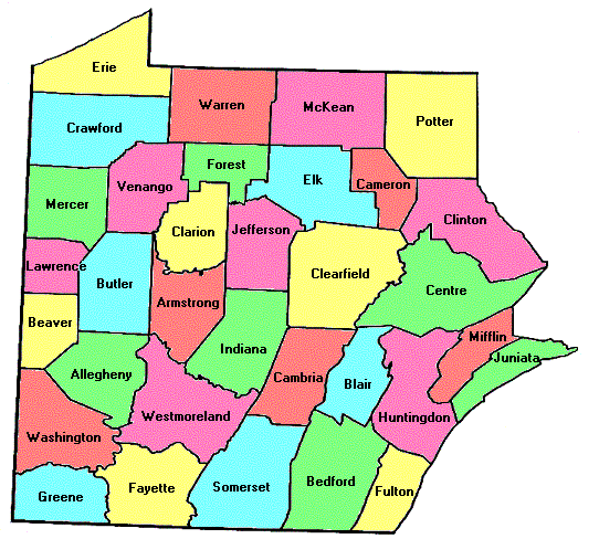
                        Click on any county for high point information.

Pennsylvania main page First Ascent List Disclaimer


    topographic chart (Acme)     aerial photograph (Flash Earth)                     Explanation

topo chart / aerial image scale:     normal     regional overview


Allegheny County - two points (1,400+ feet and 1,401 feet)

        area 1         area 2

Armstrong County - 1/2 mile NNE of Mount Tabor Village (1,740+ feet)

        topo chart / aerial image

Beaver County - two points on Stewart Hill (1,380+ feet) and Big Knob (1,383 feet)

        Stewart Hill         Big Knob

Bedford County - Blue Knob (3,120+ feet)

        topo chart / aerial image

Blair County - Schaefer Head (2,950 feet)

        topo chart / aerial image

Butler County - five areas (1,580+ feet)

        area 1         area 2         area 3         area 4         area 5

Cambria County - two areas (2,860+ feet)

        area 1         area 2

Cameron County - 1 1/2 miles west of Sixmile Hollow (2,380+ feet)

        topo chart / aerial image

Centre County - radio tower 200 feet north of county line (2,630 feet)

        topo chart / aerial image

Clarion County - BM Fisher (1,900+ feet) and one point 1/4 mile south (1,901 feet)

        topo chart / aerial image

Clearfield County - Chestnut Ridge (2,405 feet) and a second point (2,400+ feet)

        Chestnut Ridge         area 1

Clinton County - 1 mile south of Bear Wallow Camps (2,375 feet)

        topo chart / aerial image

Crawford County - USGS BM 1913 (1,913 feet)

        topo chart / aerial image

Elk County - four points in two areas (2,360+ feet, 2,369 feet and 2,376 feet)

        topo chart / aerial image 1         topo chart / aerial image 2         topo chart / aerial image 3

Erie County - 2 3/4 miles SSE of Corry (1,900+ feet)

        topo chart / aerial image

Fayette County - Seven Springs Ski Area (2,994 feet)

        topo chart / aerial image

Forest County - three points (1,940+ feet and 1,954 feet)

        area 1         area 2         area 3

Fulton County - Big Mountain (2,440+ feet) and one area (2,443 feet)

        Big Mountain         area 1

Greene County - one point 1/2 mile west of Garrison (1,660+ feet)

        topo chart / aerial image

Huntingdon County - Big Flat (2,400+ feet)

        topo chart / aerial image

Indiana County - on Chestnut Ridge (2,160+ feet)

        topo chart / aerial image

Jefferson County - one area and BM Jeff (each 2,160+ feet)

        area 1         area 2

Juniata County - spot elevation on Shade Mountain (2,228 feet)

        topo chart / aerial image

Lawrence County - four points in three areas (1,440+ feet)

        area 1         area 2         area 3

McKean County - on county line 2 miles southwest of Shaytown (2,460+ feet)

        topo chart / aerial image

Mercer County - four points 1 mile northwest of Hendersonville (1,620+ feet)

        topo chart / aerial image

Mifflin County - Broad Mountain (2,340+ feet)

        topo chart / aerial image

Potter County - Lyon Hill, Bailey Hill, and two areas (all 2,580+ feet)

        Lyon Hill         Bailey Hill         White Knoll S         White Knoll SE

Somerset County - Mount Davis (3,213 feet and State Highpoint)

        topo chart / aerial image

Venango County - 1/4 mile southeast of Powell Corners (1,755 feet)

        topo chart / aerial image

Warren County - 1 1/4 miles NNE of Clendening Corners (2,231 feet)

        topo chart / aerial image

Washington County - spot elevation 1/2 mile south of Gale (1,572 feet)

        topo chart / aerial image

Westmoreland County - radio tower 1 mile east of USGS BM Trout (2,980+ feet)

        topo chart / aerial image


Disclaimer

Attempting to reach some of the points listed in this web site can be dangerous, and could lead to accidents resulting in injury or death. Some of the summits lie in rugged and isolated regions, where even minor mishaps can escalate into a life threatening crisis. Other locations lie on private property, military bases, and other areas where access is restricted. Trespassing in these areas can result in being arrested, shot at, or worse. Right of access to these areas is constantly changing, and access in the past does not guarantee present access. By use of this web page, the reader hereby releases the trip report authors, trip report compiler, and webmaster from liability for any injury, including but not limited to monetary loss, death, and other damages that might in any way be connected with this web site.

FAIR WARNING: These are "armchair mountaineer" articles, an offering for amusement, not action. Many of these peaks are potentially life threatening, or are on private property. Adequate mountaineer training and/or owner's permission are required if you choose to pursue this list. The authors cited on this page accept no responsibility for injury, or any liability related to these route descriptions.


State Hyperlinks / Text-only Home Page Introduction Highpoint Superlatives
Highpoint Maps Topographic Prominence Highpointer Celebrities Disclaimer