Maryland State Flag Maryland County Trip Reports
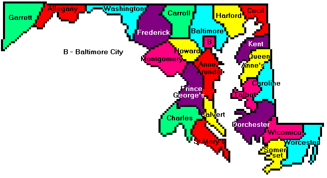
 Maryland County Map

USA Map / Home Page Click on any county for high point information

Maryland was completed on June 24, 2006 by
Chip Clark, Don Desrosiers, and Mike Schwartz.
Four additional highpointers have completed the state.
First Ascent List Disclaimer
Topographic chart links are from Glen Bock's topo links page.
Unfortunately, these links are incomplete
for several multiple area counties.
Maryland placenames pronunciation


    topographic chart (Acme)     aerial photograph (Flash Earth)                     Explanation

topo chart / aerial image scale:     normal     regional overview


Allegany County - Dan's Rock (2,895 feet) and unnamed near county boundary (2,880+ feet)

        Dan's Rock         area 2

Anne Arundel County - four areas (300+ feet)

        topo chart / aerial image

Baltimore City - three areas (480+ feet)

        topo chart / aerial image

Baltimore County - unnamed (966 feet)

        topo chart / aerial image

Calvert County - multiple unnamed areas (180+ feet) and spot elevation (188 feet)

        area 1           area 2           area 3           area 4           area 5             area 6
        area 7           area 8           area 9           area 10         area 11
        area 12         area 13         area 14         area 15         area 16         area 17
        area 18         area 19         area 20         area 21         area 22
        area 23         area 24         area 25         area 26         area 27         area 28
        area 29         area 30         area 31         area 32         area 33
        area 34         area 35         area 36         area 37         spot elevation

Caroline County - unnamed (80+ feet)

        topo chart / aerial image

Carroll County - unnamed (1,120+ feet)

        topo chart / aerial image

Cecil County - unnamed (535 feet)

        topo chart / aerial image

Charles County - multiple unnamed areas (220+ feet)

        topo chart / aerial image

Dorchester County - unnamed (57 feet) and unnamed east of Hynson (60+ feet)

        topo chart / aerial image

Frederick County - multiple points along ridge (1,900+ feet)

        topo chart / aerial image

Garrett County - Backbone Mountain (3,360 feet and State Highpoint)

        topo chart / aerial image

Harford County - six unnamed points in two areas (780+ ft and 803 feet)

        topo chart / aerial image

Howard County - two unnamed points (880+ feet)

        area 1         area 2

Kent County - unnamed (102 feet)

        topo chart / aerial image

Montgomery County - unnamed (880+ feet)

        area 1         area 2

Prince George's County - unnamed (440+ feet)

        topo chart / aerial image

Queen Anne's County - multiple unnamed points (80+ feet) including one spot elevation (89 feet)

        topo chart / aerial image

Saint Mary's County - multiple unnamed points (180+ feet) including one spot elevation (192 feet)

        topo chart / aerial image

Somerset County - two areas (49-53 ft on metric map)

        topo chart / aerial image

Talbot County - unnamed area (78 feet)

        topo chart / aerial image

Washington County - Quirauk Mountain (2,140+ feet)

        topo chart / aerial image

Wicomico County - two areas (90+ feet)

        topo chart / aerial image

Worcester County - multiple areas (59-63 feet and 60-64 feet)

        topo chart / aerial image


Disclaimer

Attempting to reach some of the points listed in this web site can be dangerous, and could lead to accidents resulting in injury or death. Some of the summits lie in rugged and isolated regions, where even minor mishaps can escalate into a life threatening crisis. Other locations lie on private property, military bases, and other areas where access is restricted. Trespassing in these areas can result in being arrested, shot at, or worse. Right of access to these areas is constantly changing, and access in the past does not guarantee present access. By use of this web page, the reader hereby releases the trip report authors, trip report compiler, and webmaster from liability for any injury, including but not limited to monetary loss, death, and other damages that might in any way be connected with this web site.

FAIR WARNING: These are "armchair mountaineer" articles, an offering for amusement, not action. Many of these peaks are potentially life threatening, or are on private property. Adequate mountaineer training and/or owner's permission are required if you choose to pursue this list. The authors cited on this page accept no responsibility for injury, or any liability related to these route descriptions.


State Hyperlinks / Text-only Home Page Introduction Highpoint Superlatives
Highpoint Maps Topographic Prominence Highpointer Celebrities Disclaimer