Colorado State Flag Colorado County Trip Reports
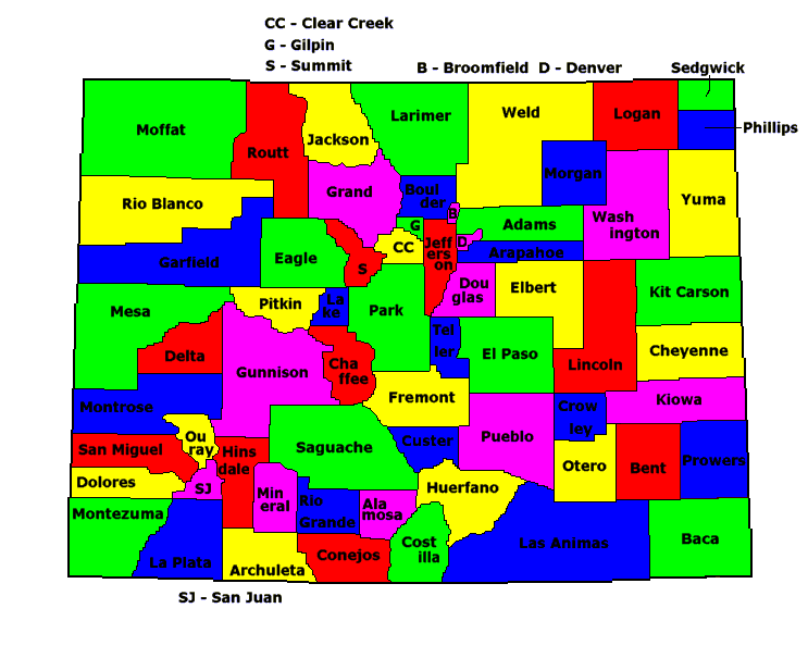
 Colorado County Map

USA Map / Home Page                         Click on any county for highpoint information

All Colorado county highpoints were completed
by John Mitchler as of September 14, 1996. Other Colorado
state completers include Bob Martin, David Olson, Bob Packard,
Dave Covill, G Vandersluis, S Mueller, C Winger, Dawn Howard,
Gerry Roach, Gary Swing, Beckie Covill, Jennifer Roach,
Jobe Wymore, Doug Hill, Dan Nielsen, Kirk Mallory,
Layne Bracy, John Kirk, Teresa Gergen, John Collard,
Phil Congdon, Renata Collard, Kevin Baker, Adam Helman,
and Patrick Thornley.
First Ascent List Disclaimer


A wealth of information alphabetically arranged by peak name
is available at Colorado Rocky Mountain Trip Reports.

Hiking Colorado's Summits : A Guide to Exploring the County Highpoints
by John Mitchler and Dave Covill will guide you to the Colorado county highpoints.


    topographic chart (Acme)     aerial photograph (Flash Earth)                     Explanation

topo chart / aerial image scale:     normal     regional overview


Adams County - spot elevation (5,665 feet) and one area (5,660+ feet)

        spot elevation         area 1

Alamosa County - Blanca Peak (14,345 feet)

        topo chart / aerial image         photo

Arapahoe County - two areas (6,210+ feet)

        area 1         area 2

Archuleta County - Summit Peak (13,300 feet)

        topo chart / aerial image         photo

Baca County - one area (5,280+ feet)

        topo chart / aerial image

Bent County - spot elevation (4,855 feet) and six areas (4,840+ feet)

        topo chart / aerial image 1         topo chart / aerial image 2         topo chart / aerial image 3         photos

Boulder County - Longs Peak (14,255 feet)

        topo chart / aerial image

Broomfield County - unnamed point (5,840+ feet)

        topo chart / aerial image         photo

Chaffee County - Mount Harvard (14,420 feet)

        topo chart / aerial image

Cheyenne County - northwest corner of county (5,250+ feet)

        topo chart / aerial image

Clear Creek County - Grays Peak (14,270 feet)

        topo chart / aerial image

Conejos County - Conejos Peak (13,172 feet)

        topo chart / aerial image

Costilla County - Blanca Peak (14,345 feet)

        topo chart / aerial image         photo

Crowley County - four areas (5,220+ feet)

        topo chart / aerial image

Custer County - three unnamed points (14,240+ feet)

        topo chart / aerial image         photos

Delta County - Mount Lamborn (11,396 feet)

        topo chart / aerial image         photo

Denver City and County - unnamed on S Kipling St, 3/4 mile S of W Quincy Ave (5,680+ feet)

        topo chart / aerial image

Dolores County - Mount Wilson (14,246 feet)

        topo chart / aerial image         photos

Douglas County - Thunder Butte (9,836 feet)

        topo chart / aerial image

Eagle County - Mount of the Holy Cross (14,005 feet)

        topo chart / aerial image         photo

Elbert County - three areas (7,360+ feet)

        topo chart / aerial image 1         topo chart / aerial image 2

El Paso County - Pikes Peak (14,110 feet)

        topo chart / aerial image

Fremont County - Bushnell Peak (13,105 feet)

        topo chart / aerial image

Garfield County - Flat Top Mountain (12,354 feet)

        topo chart / aerial image

Gilpin County - James Peak (13,294 feet)

        topo chart / aerial image

Grand County - Pettingell Peak (13,553 feet)

        topo chart / aerial image

Gunnison County - Castle Peak (14,265 feet)

        topo chart / aerial image

Hinsdale County - Uncompahgre Peak (14,309 feet)

        topo chart / aerial image

Huerfano County - 100 feet along northeast ridge from Blanca Peak (14,320+ feet)

        topo chart / aerial image         photo

Jackson County - Clark Peak (12,951 feet)

        topo chart / aerial image

Jefferson County - Buffalo Peak (11,589 feet)

        topo chart / aerial image         photos

Kiowa County - two areas (4,690+ feet)

        area 1         area 2

Kit Carson County - four areas (5,290+ feet)

        topo chart / aerial image 1         topo chart / aerial image 2         topo chart / aerial image 3

Lake County - Mount Elbert (14,433 feet and State Highpoint)

        topo chart / aerial image        

La Plata County - Mount Eolus (14,083 feet) and Windom Peak (14,082 feet)

      John Mitchler notes that the Durango-Silverton train leaves on-time.
      Don't miss it by assuming that everything is "business-as-usual"!

        Mount Eolus         Windom Peak

Larimer County - Hagues Peak (13,560 feet)

        topo chart / aerial image

Las Animas County - West Spanish Peak (13,626 feet)

        topo chart / aerial image

Lincoln County - four areas (5,960+ feet)

        topo chart / aerial image 1         topo chart / aerial image 2         topo chart / aerial image 3

Logan County - on west county line (4,940+ feet)

        topo chart / aerial image

Mesa County - Leon Peak (11,236 feet)

        topo chart / aerial image

Mineral County - unnamed peak (13,895 feet)

        topo chart / aerial image

Moffat County - Black Mountain (10,840+ feet)

        topo chart / aerial image

Montezuma County - Hesperus Mountain (13,232 feet) or Lavender Peak (13,240 feet)*

        *
Identity of the Montezuma County Highpoint - by Bob Martin.

        Hesperus Mountain         Lavender Peak         photos

Montrose County - Castle Rock (11,453 feet)

        topo chart / aerial image

Morgan County - USGS BM Shannon (4,935 feet) and one area (4,930+ feet)

        Shannon BM         area 1

Otero County - five areas (5,260+ feet)

        topo chart / aerial image 1         topo chart / aerial image 2
        topo chart / aerial image 3         topo chart / aerial image 4

Ouray County - Mount Sneffels (14,150 feet)

        topo chart / aerial image

Park County - Mount Lincoln (14,286 feet)

        topo chart / aerial image

Phillips County - eleven areas (4,110+ feet and 4,120- feet)

        area 1         area 2         area 3         area 4
        area 5         area 6         area 7
        area 8         area 9         area 10       area 11

Pitkin County - Castle Peak (14,265 feet)

        topo chart / aerial image

Prowers County - Two Buttes (4,711 feet)

        topo chart / aerial image         photo

Pueblo County - Greenhorn Mountain (12,347 feet)

        topo chart / aerial image

Rio Blanco County - unnamed point (12,027 feet)

        topo chart / aerial image

Rio Grande County - Bennett Peak (13,203 feet)

        topo chart / aerial image

Routt County - Mount Zirkel (12,180 feet)

        topo chart / aerial image

Saguache County - Crestone Peak (14,294 feet)

        topo chart / aerial image         photos

San Juan County - Vermilion Peak (13,894 feet)

        topo chart / aerial image         photos

San Miguel County - Wilson Peak (14,017 feet)

       
Wilson Peak access closures (began summer 2004) - by John Mitchler.

        topo chart / aerial image         photos

Sedgwick County - on west county line (4,120+ feet)

        topo chart / aerial image

Summit County - Grays Peak (14,270 feet)

        topo chart / aerial image

Teller County - unnamed point (13,060+ feet)

        topo chart / aerial image

Washington County - one area (5,420+ feet)

        topo chart / aerial image

Weld County - two areas (6,380+ feet)

        topo chart / aerial image         photo

Yuma County - southwest corner of county (4,440+ feet)

        topo chart / aerial image


Disclaimer

Attempting to reach some of the points listed in this web site can be dangerous, and could lead to accidents resulting in injury or death. Some of the summits lie in rugged and isolated regions, where even minor mishaps can escalate into a life threatening crisis. Other locations lie on private property, military bases, and other areas where access is restricted. Trespassing in these areas can result in being arrested, shot at, or worse. Right of access to these areas is constantly changing, and access in the past does not guarantee present access. By use of this web page, the reader hereby releases the trip report authors, trip report compiler, and webmaster from liability for any injury, including but not limited to monetary loss, death, and other damages that might in any way be connected with this web site.

FAIR WARNING: These are "armchair mountaineer" articles, an offering for amusement, not action. Many of these peaks are potentially life threatening, or are on private property. Adequate mountaineer training and/or owner's permission are required if you choose to pursue this list. The authors cited on this page accept no responsibility for injury, or any liability related to these route descriptions.


State Hyperlinks / Text-only Home Page Introduction Highpoint Superlatives
Highpoint Maps Topographic Prominence Highpointer Celebrities Disclaimer