Small Pennsylvania State Map East Pennsylvania County Trip Reports East Pennsylvania County Map

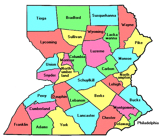
Tioga Bradford Susquehanna Wayne Lycoming Sullivan Wyoming Lackawanna Union Montour Northumberland Columbia Luzerne Pike Monroe Schuylkill Carbon Snyder Northampton Lehigh Berks Bucks Montgomery Dauphin Lebanon Philadelphia Delaware Chester Lancaster York Adams Cumberland Franklin Perry Philadelphia

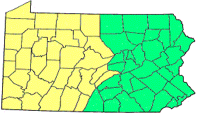
Click on either region from the map above
to access the corresponding reports.
                        Click on any county for high point information.

Pennsylvania main page First Ascent List Disclaimer


    topographic chart (Acme)     aerial photograph (Flash Earth)                     Explanation

topo chart / aerial image scale:     normal     regional overview


Adams County - 1 mile north of Ram Hill (2,060+ feet)

        topo chart / aerial image

Berks County - on Blue Mountain (1,680+ feet)

        topo chart / aerial image

Bradford County - radio tower on Armenia Mountain (2,440+ feet)

        topo chart / aerial image

Bucks County - two areas (970+ feet) and Haycock Mountain (960+ feet)

        area 1         area 2         Haycock Mountain

Carbon County - Lake Mountain (2,180+ feet)

        topo chart / aerial image

Chester County - Welsh Mountain (1,080+ feet)

        topo chart / aerial image

Columbia County - northeast corner of county (2,420 feet)

        topo chart / aerial image

Cumberland County - on Blue Mountain 2 1/2 miles NNE of McKinney (2,270 feet)

        topo chart / aerial image

Dauphin County - two points (1,763 feet and 1,771 feet)

        area 1         area 2

Delaware County - unnamed point on county line (500+ feet)

        topo chart / aerial image

Franklin County - Big Mountain (2,458 feet)

        topo chart / aerial image

Lackawanna County - one point on Moosic Mountains (2,323 feet)

        topo chart / aerial image

Lancaster County - 200 feet SW of most northerly county point (1,180+ feet)

        topo chart / aerial image

Lebanon County - spot elevation on Stony Mountain (1,651 feet)

        topo chart / aerial image

Lehigh County - two areas (1,674 feet and 1,660+ feet)

        area 1         area 2

Luzerne County - Cherry Ridge (2,460+ feet)

        topo chart / aerial image

Lycoming County - two points 3/4 mile east of Devils Elbow (2,380 feet)

        topo chart / aerial image

Monroe County - Kistler Ledge (2,215+ feet), Dresser Hill (2,200+ feet) and Pimple Hill (2,212 feet)

        Kistler Ledge         Dresser Hill         Pimple Hill

Montgomery County - Mill Hill (700+ feet)

        topo chart / aerial image

Montour County - two points on Montour Ridge (1,380+ feet))

        area 1         area 2

Northampton County - 200 feet northeast of lookout on Blue Mountain (1,695 feet))

        topo chart / aerial image

Northumberland County - Boyers Knob and 1/2 mile ESE (both 1,780+ feet)

        Boyers Knob         area 1

Perry County - south county line on Blue Mountain (2,260+ feet)

        topo chart / aerial image

Philadelphia County - on Summit Street in Chestnut Hill (440+ feet)

        topo chart / aerial image

Pike County - two areas near Lake Russel (2,115 feet) and Lake Jamie (2,100+ feet))

        area 1         area 2

Schuylkill County - Bears Head (2,094 feet)

        topo chart / aerial image

Snyder County - two points on Shade Mountain (2,180+ feet)

        topo chart / aerial image

Sullivan County - (former) lookout tower on North Mountain (2,585 feet)

        topo chart / aerial image

Susquehanna County - North Knob on Elk Hill (2,693 feet)

        topo chart / aerial image

Tioga County - 1/4 mile NW of Beecher Hollow on Cedar Mountain (2,543 feet)

        topo chart / aerial image

Union County (Paddy Mountain, county line on Buffalo Mountain and Jones Mountain (each 2,160+ feet)

        Paddy Mountain         Buffalo Mountain liner         Jones Mountain

Wayne County - spot elevation on Mount Ararat (2,656 feet) and two points (2,640+ feet)

        area 1         area 2

Wyoming County - three points in two areas (all 2,380+ feet)

        area 1         area 2

York County - one point 2 miles southwest of Beavertown (1,412 feet)

        topo chart / aerial image


Disclaimer

Attempting to reach some of the points listed in this web site can be dangerous, and could lead to accidents resulting in injury or death. Some of the summits lie in rugged and isolated regions, where even minor mishaps can escalate into a life threatening crisis. Other locations lie on private property, military bases, and other areas where access is restricted. Trespassing in these areas can result in being arrested, shot at, or worse. Right of access to these areas is constantly changing, and access in the past does not guarantee present access. By use of this web page, the reader hereby releases the trip report authors, trip report compiler, and webmaster from liability for any injury, including but not limited to monetary loss, death, and other damages that might in any way be connected with this web site.

FAIR WARNING: These are "armchair mountaineer" articles, an offering for amusement, not action. Many of these peaks are potentially life threatening, or are on private property. Adequate mountaineer training and/or owner's permission are required if you choose to pursue this list. The authors cited on this page accept no responsibility for injury, or any liability related to these route descriptions.


State Hyperlinks / Text-only Home Page Introduction Highpoint Superlatives
Highpoint Maps Topographic Prominence Highpointer Celebrities Disclaimer